|
A BRIEF HISTORY OF CITY DIRECTORY MAPS OF CLEVELAND, OHIO This is a casual account of a genre of maps I am calling "city directory maps," not because they always were affiliated with (much less accompanying) the published city directories of Cleveland, but rather because many of them were so affiliated and the others looked similar enough to have served the same audience, during the nineteenth and early twentieth centuries. These maps were usually printed on one side, ranging in size from about 2 feet by 3 feet to about 3 feet by 4 feet and sold folded several times, with or without a cover. There was often a panel on the reverse side printed with a title. The scope of their coverage expanded as the city grew during the nineteenth century, but always showed "greater Cleveland" in some form. They usually contained data in color, such as streetcar lines or ward boundaries, and may have had an elaborately-engraved title block. I have divided this group of maps into four periods, representing the major publishers active in each period. Since publishers tended to stay with a particular title, style and format, this classification will reflect the maps, as well. The periods are 1) The early publishers, 1848-1873, 2) the City Directory Company and H.B. Stranahan, 1874-1905, 3) the Forman Bassett Company and John Mohr, 1906-1930, and 4) the Montcastle and Commercial Survey Companies, 1931 to present. This discussion is taken from my studies in the mid-1990s and a presentation I made to the Northern Ohio Bibliophilic Society, while I was employed by the Western Reserve Historical Society, processing its unparalleled local history map collection. For the details behind this discussion, and for examples of the maps I mention, please see the Society's color microfilm of their map collection and the accompanying database of titles. The Cleveland Public Library map collection may also have some of these titles. I should point out that the exact relationship between the various publishers, printers and engravers of maps during the time of this paper is not clear. When I speak of "rivals," I am referring to rival titles and the publishers may or may not have been corporately connected. There are examples where two titles were being published in apparent competition, when an examination shows that the publishers were working together on other titles. Indeed, the Cleveland Directory Company may well have merely purchased titles from local printers, who then issued their own titles at the same time. This whole question needs close examination to clarify these relationships, but for present I will treat rival titles as the issue of rival publishers. Early Publishers, 1848-1873 This first period covers the maps published between approximately 1848 and 1873, coinciding with the serial publication of city directories for the rapidly-growing city. | |
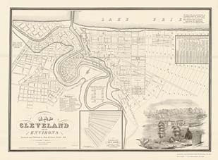 Merchant, 1835. From Rails and Trails. Click for their 300 dpi Djvu version (simple Djvu plug-in required). |
The first known published map of Cleveland was Ahaz Merchant's Map of Cleveland and Its Environs, published in 1835. The first directory of Cleveland was also published then, but I am not considering this a "city directory map" because it showed much detail, such as real estate parcel information, and wasn't followed by later versions of the same title. Merchant was a surveyor and his maps may have been marketed more for developers than travelers. His legacy of maps is better found amongst the commercial atlases that began publication in 1874. |
 Knight & Parsons, 1853? From Rails and Trails. Click for their 600 dpi Djvu version (simple Djvu plug-in required). |
The first city directory map, that I know of, was one published with Smead and Cowles' General Business Directory, in 1848. Over the next quarter century, similar maps were published by other directory publishers, such as Slatter and Callan (1852), Knight and Parsons (1853?) [left], Spear and Denison (1855), Peirce (Cleveland Almanac and Businessman's Directory, 1857), William H. Boyd (1857), J.H. Williston (Directory of the City of Cleveland, 1861-62), the Cleveland Leader Printing Company (1868), Ingham and Bragg (1868) and Stringer (1873). |
While Smead and Cowles and The Cleveland Leader each managed to produce maps for at least two different years, the common denominator for all these maps in this period is that they largely published only once or twice. Or, since there are years that lack surviving titles, perhaps these are only the ones we know about. Nevertheless, when compared to the publication regularity of the titles in the following periods, the maps of this period are characterized by their singularity and the turnover of publishers. This undoubtedly reflects the volatile nature of the young printing and publishing industry in Cleveland, generally. The Cleveland Directory Company and H.B. Stranahan, 1874-1905 Following the Panic of 1873, new publishers began producing maps of Cleveland and over the next thirty years the primary two rivals -- The Cleveland Directory Company and H.B. Stranahan -- provided a degree of regularity not witnessed before in Cleveland cartographic circles. W.S. Robison and Company began this series with a map in the Annual City Directory of 1874. The following year he is teamed up with J.B. Savage in the firm of Robison, Savage and Company and produced maps for the Cleveland City Directory for several years under the title "The Only Correct Map of the City of Cleveland." The lithographer on these was W.J. Morgan. In 1878-79, Robison left the firm, which became known as Savage and Annewalt. They continued producing the "Only Correct" title for the Cleveland Directory Company until at least 1882. After which time Savage and Annewalt vanished and the Cleveland Directory Company (a.k.a. Cleveland Directory Publishing Company) is not shown to be affiliated with any other firm until the 1920s. |
|
 Cleveland Directory Company, 1894. From Rails and Trails. Click for their 150 dpi Djvu version (simple Djvu plug-in required).
|
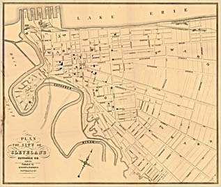
When Savage and Annewalt leave the scene, the title published for the Cleveland Directory Company becomes "A Map of the City of Cleveland," in various versions. A map with that title is also produced by J.S. Morse, in the early 1880s, by atlas publisher Mueller, in 1898 and by the Whitworth Brothers in the early years of the twentieth century. Their relationship to the Cleveland Directory Company, if any, is unknown. |
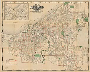
 H.B. Stranahan, 2nd. ed., 1893-4. From Rails and Trails. Click for their 300 dpi Djvu version (simple Djvu plug-in required). |
The chief competing map during the last quarter of the century was H.B. Stranahan's "Map of Cleveland and Vicinity." Beginning at least as early as 1893, Stranahan's title is distributed every year until 1905. Stranahan's maps gave edition numbers and were up to the eighteenth edition before he ceased issuing them. His first known map included a lengthy statement outlining his goals for the map. |
The Burrows Brothers publishing maps during this period, as well, but not in the quantity as the Cleveland Directory Company and Stranahan. Since Burrows was a major stationers firm, they undoubtedly were merely distributing a title created for them by some unnamed printer. The Forman Bassett Company and John Mohr, 1906-1930 | |
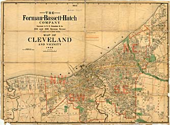 Forman, Bassett Hatch, 1908 (No. 3). From Rails and Trails. Click for their 150 dpi Djvu version (simple Djvu plug-in required). Forman, Bassett Hatch, 1908 (No. 3). From Rails and Trails. Click for their 150 dpi Djvu version (simple Djvu plug-in required). |
In 1905, Stranahan published the last edition of his "Map of Cleveland and Vicinity," but that year (and the next) the same title was published by the Forman Bassett Hatch Company, who were stated to be "the successors to Stranahan." All during the first decade of the century, FBH issues "Number 2" and "Number 3" versions of that title, but by the 1920s Hatch disappears from the firm, which is simply Forman Bassett into the 1930s. Forman Bassett may also have acquired the Cleveland Directory Company about this time. "Forman-Bassett Publications" (1928) |
|
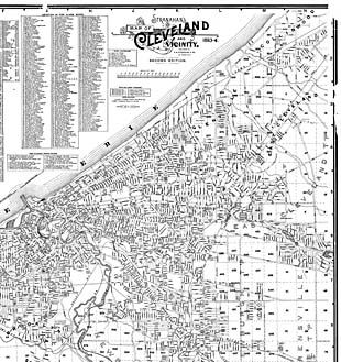
Meanwhile, John Mohr has taken over the "Map of the City of Cleveland" and, perhaps, the Cleveland Directory Company itself. His name actually first showed up on a CDC title in 1900, during the second period (above), but it wasn't until 1910 that his name showed up with any regularity. Since his maps were somewhat larger than what was normal for those discussed here, and rather thin and fragile -- perhaps in response the increasing size of the metropolitan region and the resulting difficulty in folding larger maps -- it may be that fewer of them survive. |
|
 A.C. Wagner, 1924. From Rails and Trails. Click for their 150 dpi Djvu version (simple Djvu plug-in required). Others producing similar maps during this period include the A.C. Wagner Company. |
|
|
The Montcastle Map Company and the Commercial Survey Company, 1931 to Present The reign of the large, folded street guide maps came to an end with the coming of the automobile. The range of the auto was such that the single sheet map had trouble showing the level of detail contained in the traditional city directory map. As the telephone book began to replace the city directory as the primary means of looking up people's addresses, so to did the road maps -- handed out free by the oil companies, such as Gousha's Shell Oil maps -- changed the nature of the street maps. The Montcastle Map Company purchased the Forman Bassett company and used the latter's "Dissected Map and Street Guide" (1928 or earlier) as the model for its bound book format, while publishing road maps for the Cleveland Automobile Club and the Hi-Speed Blue Flash Oil Company on the side. In the 1940s, the Commercial Survey Company, started by a former Forman Bassett employee, purchased Montcastle and continued the book format, albeit with today's familiar red cover. The Cleveland Directory Company continued appearing on map titles, but during the 1930s and 1940s it was producing them as the "Official Arrow Map of Cleveland and Vicinity." There is still much to learn about the various map publishers, printers, engravers and distributors and their relationships with one another over time. This is only meant to be an outline of some tentative conclusions and a guide for further research.
This page was created by William C. Barrow and I bear all responsibility for any errors it may contain. It reflects more the sum of what I've encountered about local maps to date than any systematic research. Therefore, there may be many titles I have never seen which may alter some of my conclusions, but I'm comfortable with the basic outlines of this presentation. I welcome any additions, corrections, suggestions, criticisms or questions anyone may have on this topic. Cleveland Cartography -- "Map History" Created December 12, 1999 © Copyright 1999-2008 by William C. Barrow
|
|