|
The early days and the establishment of Warrensville Township
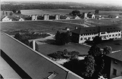
The Founding of Warrensville Township The first recorded inhabitants of the area known as the Western Reserve were native Americans from the Erie tribe. The Western Reserve essentially consisted of the present day counties of Erie, Huron, Lorain, Medina, Summit, Portage, Trumbull, Ashtabula, Geauga, Lake and Cuyahoga. After many battles with the occupying tribes and The American Revolution, The Commonwealth (State) of Connecticut won the rights and title to this large expanse of land. Much of the land was given to land owners from Connecticut who had suffered losses at the hands of the British during the Revolution. Three million acres were held back however, and in 1795, sold to a group of investors for $1,200,000 (less than 40 cents per acre). The man selected by the investors of The Land Company to explore the new territories was General Moses Cleaveland. He was to survey the terrain and make peace with the surrounding Indian tribes. In 1796, after making an offering of peace to the Indians of the area, Moses Cleaveland landed on the shores of the Cuyahoga River. In the early 1800's Townships were established to provide the early settlers a means of governing themselves. Each Township had approximately 16,000 acres and measured 25 square miles. The government of each Township was headed by a clerk, a treasurer, a justice of the peace, a constable, and three trustees. As time went on a Board of Education and additional officals were established. Warrensville Township was established in 1814 and contained what is today the City of Beachwood. Numerous attempts to establish what would become Warrensville Township were unsuccessful. Jacob Cattern and three other pioneers arrived in the area in 1807 and deemed it worthy of a settlement. But their attempt was foiled by a stubborn bear, or more appropriately, their own folly. Jacob and his cohorts trapped the bear while exploring the area and decided they would kill it in a most unusual way. They would chop down a tree which was towering over the bear and the tree would fall upon the unsuspecting animal and kill it. While attempting to execute this scheme a limb from another tree fell on Jacob and subsequently killed him. The disappointment was too much for the remaining three pioneers and they abandoned their plans. The initial failures of pioneers such as Jacob Cattern did not persist for long. Soon after Cattern's unlikely demise, Daniel Warren of New Hampshire settled in the area. Warren settled first in Lake County, then in Newberg Township and finally in 1810 he moved to Warrensville Township with his wife and first son, who died in the same year, making him the first person to die in the township. Later that same year Warren's second son was born, making him the first non-Indian born in the area. The Township bear's Warren's name for his determination in establishing the settlement. 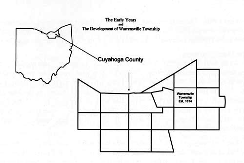 The Shakers In 1811 Jacob Russell, a Revolutionary War veteran, acquired 475 acres in the western portion of the township. Several years later his son, Ralph, traveled to Lebanon, Ohio and observed a Shaker Village. The Shakers were a group of peaceful people with surprisingly progressive views toward women and marriage. Ralph was so impressed with the group that he converted. Upon returning home to Warrensville in 1822, he formed a religious Shaker organization known as "The Valley of God's Pleasure." The land they occupied was labeled the North Union Shaker Community. The Shakers established a total of 19 villages in the country. The North Union Shaker Community sustained itself quite well and was at one point a thriving community, but farming proved to be an unprofitable enterprise because of the limited potential of the soil. The zealous imagination of the Shakers was well known, though, and they soon found new and ingenious ways to turn a profit. Creative members of tthe Community formulated a plan to dam Doan Brook, which ran from what is now the Shaker area through Rockefeller Park north to Lake Erie, in order to facilitate the operation of a gristmill and a sawmill. At their peak, the Shakers had 1300 acres and 60 buildings. The group was concentrated in three areas of the community: The North Family resided near what is today Coventry and South Park; The Center Family lived near the intersection of Lee Rd. and Shaker Blvd.; and the East Family thrived near Shaker and Fontenay. The advent of modernization in the US inevitably rendered the Shakers' simple lifestyle as both archaic and unprofitable. Their resistance to advancement disillusioned many of its members and consequently membership plummeted. The Shakers found that their alternate lifestyle was considered strange by the general public which led to extreme difficulty in converting others into the group. By 1888, there were only 27 Shakers left in the entire state of Ohio and the group in Warrensville quietly disbanded. The few remaining Warrensville Shakers moved and joined other groups in southern Ohio.. The property once owned by the Shaker community was bought by a group of investors from Buffalo that did very little with it until 1905, when the Van Sweringen brothers took out their first of many options to sell and develop the land. The Manx Farmers As the Shaker farming community broke up and moved on, there were other families developing farms in Warrensville Township in what would later become the Village of Beachwood. These other farmers first arrived from The Isle of Man, a small island in the Irish Sea. In 1820 the first of these farmers, known as the Manx (pronounced Manks), to settle down in the area were the Corletts. In 1822 the Corletts were joined by the Kellys and the Kneens. By May of 1824 at least 70 other members of the Isle had moved across the ocean. Included in this group were John and Jane Teare and their six children. The Teare voyage to the Township was a long and difficult one which, because of the lack of an established road system, included traveling from Fairport Harbor all the way to Warrensville on foot. But they loaded their belongings on the back of an ox and persevered. When they finally arrived in the area, John Teare bought 80 acres of land on the north side of Kinsman Rd. (Chagrin Blvd.) just east of Green Rd. next to the Corletts. The Teare family established a long history in the area. John Teare, his wife Jane, and his daughter Catherine were all buried in the Warrensville East Cemetery. It is located in what would later become Beachwood on Green Rd. south of Chagrin. John Teare's son John Teare II, continued to manage the farm for the family. In 1858 he married Mary Ann Walkden whose family owned, at one time, all the land west of Richmond to Warrensville Center Rd, and south from Kinsman Rd.to Harvard Rd. Mary Ann was raised in a log cabin located on the west side of Richmond Rd. between Kinsman and Harvard. The cabin was later replaced by a brick home built by her brothers. In the 1970's that same house was used as a haunted house for fund raising events. John and Mary Ann left the area and purchased a farm on North Woodland (now Fairmount) east of Lander and raised six children. The many other Manx families in the area expanded beyond common farming of the normal fruits and vegetables and began growing sugar cane. In addition to the agricultural development, the families in this area also started a small textile industry which produced various fabrics for weaving and buttons. Some of the Manx family names included Kerruish, Radcliffe, Shimmon, Quayle, and Watterson. Many of them were buried near the Teares at the Warrensville East Cemetery which is now known as the Beachwood Cemetery. The Early Days Two major Indian trails were improved to plank roads in 1817. Warrensville Center Rd., then known as Center Street, ran north and south and Kinsman Rd. ran east and west. Both of these streets played an important part in the development of the farms from Newburg Township to Chagrin Falls, and Euclid Township to Bedford Township. In 1824 the Ohio legislature passed an act laying out State Route 422 which, when completed, would run from the center of Cleveland through Warrensville to the town of Kinsman. Kinsman Rd. was a major east/west route for stage coaches that would be going in and out of Pittsburgh. These two streets became the center of activity in the early to mid 1800's for the Township. The Township built its first school house in this area. The first teacher to practice in the area was named William Addison. By 1878 seven other school houses had been constructed, each forming its own district within the Township. Two of the districts were located in Beachwood. One was built on Kinsman where Pavilion Mall shopping center now stands and was known as the Teare school house. The other one, known as the Lewis or (LaRue) school house, was located on North Woodland (Fairmount) at Richmond. This corner was known as "LaRue's Corners." The Centenary Methodist Church ,which is still standing today, was built next to the school house in 1884. In 1916 the church was renovated. When North Woodland was widened in approximately 1928, the church was moved a few yards back to its present location. It is now owned by the City of Beachwood and is used for a variety of administrative offices.  According to the Cuyahoga County Atlas map of 1874 there was another church in the area located on the east side of Richmond Rd. just south of South Woodland, which at the time was known as Buckeye Rd. By 1870, the Township had grown in size and was home to 1,429 people. The early 1900's saw significant development in the Warrensville Township area. Many government buildings were constructed in the southern part of the Township. Also, in 1902, the land was purchased for the development of Highland Park Cemetery. Portions of this land belonged to William Blair, whose home is still standing. The home was later moved north toward the road, and is now used to house the maintenance department of the Cemetery. It is said that one of the early burials included an Indian named Nowalewagetka, the son of Chief Thunderwater. Nowalewagetka, in accordance with Indian rituals, was buried at night and standing up facing the east towards the sunrise. Camp fires burned into the night to allow for festive dances to take place. In 1910 Sam Newman, a Board member of The Anshe Emith Congregation, which is now Park Synagogue, decided to search on his horse for a new location for the synagogue's cemetery. At the time the synagogue was located at 37th and Woodland. In 1922 it was moved to E.105th and Grantwood. And finally, in 1950, it moved to Mayfield Rd. east of Lee which is its present location. Its cemetery on Fir Avenue on the west side was nearing capacity and Mr. Newman had decided that he would search on the east side for a new location. During his trip east he was delayed by a blizzard and had to take up residence with a family that lived at the corner of Kinsman Rd. and Richmond Rd. Newman stayed with this family, the Rindfleischs, for a night and relayed the details of his search to them. When the Reinfleisch's heard that Sam was looking for land they offered to sell theirs to the synagogue with the condition that they be allowed to stay on and maintain the property for the synagogue. The proposal sounded acceptable to Newman and he decided that the Rindfleisch's farmland would be an ideal place for his cemetery. This unique relationship developed into a long time commitment between the parties involved and continued for many generations. But the agreement between Newman and the Rindfleischs angered many of the area farmers. They agreed that the situation was unacceptable to them and decided to start a petition to terminate the plans for the cemetery. The farmers' petition called for a referendum-type vote on the topic of the cemetery by the residents of the Township. There was, however, a state law that said that once a body is buried on a piece of land, that land must remain a cemetery, no matter what the citizens of the community want. Allegedly, as soon as the synagogues board received this legal advise, a body was found and buried on the farm. The cemetery continues, even today, to be one of the best maintained cemeteries in the area. Beachwoods other cemetery known as Warrensville East is located on the northwest corner of Halburton and Green Rds. In 1853 the land was deeded to the township by William Warren. The oldest stone is dated 1813. The orignal entrance on, what is now known as Old Green Rd. Graves include those that fought in the Revelutionar war, the War of 1812, and the Civil War. Today the cemetery is maintained by the city of Beachwood. In 1913 The Sunny Acres Sanitarium was built to house people with tuberculosis who needed time to convalesce from their illness. In addition to this modern medical institution the City of Cleveland decided to build its prison in the area. Under the direction of Dr. Harris R. Cooley, the pastor of the Cedar Ave Church of Christ, a large tract of land was developed for the prisoners to farm. This area became known as Cooley Farms. By the year 1912 the City of Cleveland had over 2000 acres dedicated to Cooley's Farm. This establishment, known at that time as a model facility, developed many practices which would later be adopted by other prisons. For instance, the inmates ran a dairy, grew many of the vegetables they would consume, and ran a small quarry.
| |
|
|
|
|