|
The Early Days 1915 - 1939
An election was held on June 15, 1915 in order to establish the Village of Beachwood. There was only one negative vote out of 47 possible votes. The vote was held in a school house located on the northwest corner of Richmond Rd and North Woodland Rd.(now known as Fairmount). This schoolhouse was known as the LaRue School House and at times the Lewis schoolhouse. LaRue (also spelled LaRoe) owned land on several corners of Richmond Rd. and North Woodland Rd. in 1874. Omar Lewis owned the land where the school house was located which explains why the school took his name at various times. 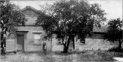 LaRue Homestead. 1890's. Thought to be located on the southeast corner of Richmond Rd. and Fairmount Blvd. photo courtesy of Mr.Robert LaRue On June 26,1915 the Trustees of Warrensville Township accepted the incorp oration and the Village of Beachwood was officially established. The proposed closing of one of two schools in the area caused the group to form the Village. The school house in question was The Teare School and was next to John Teare's property on Kinsman Rd. where Pavilion Mall now occupies that land. The Village started to hold regularly scheduled council meetings on October 4th, 1915 after receiving certification from the State of Ohio. Among those present at the first meeting were Messrs. Bieger, Burk, Fehr, Fry, McVeigh, and Walkden. The second meeting , two weeks later also included W. W. Corlett, R. N. Warren and S. Lewin. The meetings were first held at the LaRue school house. However, for several years after their initial meetings the group met at the home of various council members. Many meetings were held at the home of Councilman Walkden, who lived on North Woodland Rd.(now Fairmount Blvd.) west of Richmond Rd on the south side of the street. The first Mayor and President of the Village Council was W.W. Corlett. The clerk was R.N. Warren. The position of Mayor and Clerk would rotate among various founding fathers of the Village during those initial years. The correct spelling of the original village name is ambiguous. Many people believe that the name of the Village was supposed to be spelled "Beechwood". Early minutes from council meetings spelled it as two words "Beach Wood". The problem originated when an incorrect spelling appeared on the incorporation papers which were sent to the state capitol. Those incorporation papers were returned by the state with the spelling of "Beachwood" and it was felt to be too much of a hassle to change it. One might ask then, why, in 1928, when the Fairmount Blvd. school house was built, was the name of the school spelled "Beechwood" One possible answer could be that the leaders of the schools felt it was important to spell the name corresponding to the original intention of the community. Another possibiliominent position the schools held in the community and wanted to remain loyal to the village's heritage. There are other less factual thoughts about the name however this one seems to have the most logic and credence behind it. It should be noted that Beachwood Boulevard was spelled Beechwood Boulevard until the mid 1980's. Farming was the primary source of commerce during those formative years. The farmers and their families would go into Chagrin Falls or South Euclid to sell or barter. South Euclid was usually the market of choice for Beachwood farmers because many of the families belonged to St. John's Lutheran Church on Mayfield Rd. near Green Rd. In fact, several families from Beachwood sent their children to St. John's School instead of BeachwoodSchools. If they chose to go to Chagrin Falls, they usually took the Interurban railroad. The interurban railroad ran up Kinsman (Chagrin) from East 116th St. to Chagrin Falls. The rail line opened back in the 1895. There were several stops in the Beachwood area including #18 at Highland Park Cemetery. ( Interestingly, Henry A. Eickoff moved into the Village in 1917 and set up his flower shop at 21207 Kinsman Rd. across the street from the cemetery, and the flower shop still stands at the same site by the name of Gali's.) Another stop #19 along the Interurban Rail was at Green Rd. and Stop #20 was at 23600 Kinsman. Stop #21 was known as the Sanitarium stop. At this stop there was a single track rail line that ran south through t he woods to the Sunny Acres sanitarium. Today stop #21 would be where Mercantile Rd. is located. The line continued to Stop #22 at Richmond Rd. and, Stop #23 was just before the bend in the road where the bridge now goes over I-271. Stop #24 was just after the bend in the Road. The Interurban's existence fueled the development of several small businesses on Kinsman Rd. Most of them were just East of Richmond Rd. In 1925 the rail line stopped operating due to financial problems possibly precipitated by the rise of automobiles. 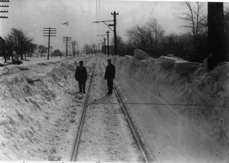 Kinsman Road street car track and two conductors. To the left of the track is Kinsman Road looking east. Photo taken February 20th 1920. Photo courtesy of Les Giesler. In 1904, while the area was slowly developing, two brothers purchased their first piece of property in the Heights area. Known as "the Vans," Mantis and Oris Van Sweringen would become the primary instruments of change and development on the east side. The Vans came from a farming community in Wooster. When they came to Cleveland their name was not Van Sweringen, but simply Sweringen. After their mother died in 1890 they moved to Cleveland and lived on E. 105th just south of Cedar Rd. They attended Bolton School at E.89th and Carnegie Rd. and Fairmount School on E. 107th. During the summer months they had a paper route that took them up past Doan Brook to what is now Shaker Heights and Cleveland Heights. Oris workedas an office boy at the Bradley Chemical company on the top floor of the Society for Savings Building located on Public Square, Downtown. He met many influential business people during his work there. The Vans first real estate deal was an option on a home at the east end of Carnegie. They sold it within 24 hours and made $100.00. Ben Jenks, a close lifelong friend of theirs persuaded them to buy a few lots on Cook Rd. on the west side in the developing community of Lakewood. That venture would be their first failure. For several years they had to do business using their sisters' names because theirs was not credit-worthy. It was then that they chose to add the "Van" to the front end of their name. Their first purchase in 1904 in the "Heights" consisted of 2.1 acres which they bought for $1500.00 per acre. That piece of property is currently Roxboro Middle School. They realized that in order to sell homes in thearea they would need a streetcar to service this area. They were able to convince John Stanley, the President of the Cleveland Railway Company, to run a street car east out Fairmount Blvd. While this was helpful the relationship did not last very long because The Vans wanted to develop and operate their own streetcar up Cedar to Fairmount and then south across Coventry. In 1905 the Vans began buying options on the land originally occupied but abandoned by the "Shakers" in 1889. The "Shakers" had sold the land to a group of Cleveland investors who made a few improvements to the area in conjunction with the Cleveland Parks Department. These improvements were limited to constructing roads and park-like areas around Lower Shaker Lakes and Doan Brook. The Cleveland group decided to sell the tract of land to a group of Buffalo capitalists headed by W. H. Gratwick. The Buffalo group also did very little with the land. The roads had fallen into disrepair and were overgrown. The Vans, who had been having a fair amount of success selling land from the options they had taken, decided to buy all of the remaining land that the Buffalo group had owned in 1906. This essentially was the site of the original Shaker Village. The Vans realized that in order to develop the property they would need a way to get the wealthy industrialists and their servants into the area. Accordingly, they constructed the streetcar system they had originally formulated. The line ran along Cedar Rd. and continued up Fairmount to Coventry Rd. The also built a shopping center around what was called Moreland Circle, changed the circle to a square and renamed it, appropriately, Shaker Square. Fairmount Blvd. was the first major thoroughfare to be developed. Residential lots on this street along with the other streets that had large mansion type homes were sold directly by the Vans. The lots on the numerous side streets were sold through syndicates. Instead of one person buying one lot, they sold a group of lots or a parcel of land to a group of investors. Their idea was that if a group of people bought the land they would be assured of selling land for houses because at least some of the group's investors would have friends in need of a new house. They hired a top-notch engineering firm, F.A. Pease Engineering Co., to design the roads and parkways and also to establish the design standards of the houses. The Vans' successescontinued throughout the decade of the twenties and their community expanded into the first planned development of its size in the country. They built a home for their sisters on South Park Blvd. between Eaton and Lee and lived themselves on a 477 acre expanse of land in Hunting Valley which they called Daisy Hill after a Mrs. "Daisy" Jenks. Around 1913 they developed a plan to take their community as far east as Chagrin River Rd. Two key elements needed in this plan were the development of a light rail train system then known as a street car and plenty of country clubs for the wealthy industrialists that would buy the homes. The name of the development was "Shaker Country Estates." This new phase of development started at Green Rd. and ran as far east as SOM Center Rd. It went as far south as Kinsman and was bordered on the north by Fairmount Blvd. This new territory was divided into 9 areas. They were: Sydenham Green (Located in Shaker Hts.)Byron, Rye, Sydenham, E. and W. Belvoir, Westchester, Holmwood, Glenmore, Duffield Downs (Located in Shaker and Beachwood) (Sub div #45) Duffield, Hazelmere,Wimbledon, Hardwick, Brucefield, Crafton, and E. and W.Sulgrave. Canterbury Club (Sub div # 29) Halworth, Halburton, Rexway, Stratton, Farnsleigh,and Belvoir area Crestwood Park (Sub div #32 - (Block 1) Halburton, Bryden, Letchworth, Hermitage, Brandon, Havel, and Falkner (now known as Woodside) Funston, Conway & Moncrest which were never built. Bernwood Estates (Sub div # 33 (Block 4) Hurlingham, Hendon, Bernwood, Annesley, Selkirk, and one street that was never built: Lawton Kersdale Area (Located in Pepper Pike) Belgrave, Kersdale, Edgedale, Alvord and the following that were never bu ilt: Aldwych, Curzon, Bernwood extension and Dorset Belcourt Acres (Located in Pepper Pike) Belcourt, Bryce and Lawton Lane. along with two streets that were never b uilt: Cheltenham and Windsor Bolingbrook Area (Located in Pepper Pike) Bremerton, Bolingbrook and Kersdale Shenley - Kelverden Area (Bounded by Richmond, Brainard, S. Woodland & Kinsman) Two streets were put in east of Brainard but never dedicated. They are Sh enley and Belcourt. The streets that were not built were, Chalton, Halburton, Kelve rden, and Huntley.Sydenham Greens, Duffield Downs, and Canterbury Club developments were de signed for the homes that exist there today. The other 6 developments or "Blocks" were originally designed for estate type homes found in earlier Van Sweringen Developments along Shaker Blvd. in Shaker Heights. The Vans sold these lots of land in a different manner as they had sold much of their land in Shaker Heights.. Each area or block of land was divided into large estate sized lots that ranged from 6 - 10 acres. Stringent deed restrictions were created within these blocks that dictated what type of home could be built. Prospective buyers were considered "subscribers" and they purchased the right to buy a lot with one of the "blocks" or developments. When the number of buyers equaled the number of lots available in the "block", the Van Sweringen Company would notify the group of potential owners that there would be a drawing. The first name pulled had the opportunity to pick the choice lots. If you did not show up or send a representative the Van Sweringen Company representative would select a lot for you. Clearly this was one drawing you would want to be present at. The price of the lots ranged from $2250.00 an acre to $4250.00 an acre. At the time of signing the subscription agreement a buyer or subscriber would be required to deposit $1000.00 for each parcel of land if it was less than 8 acres. If their intended purchase was multiple lots and/or over 8 acres the deposit was $500.00 per acre. The balance was to be paid over the time period that the Van Sweringen Company perceived the development or block to fill up. Therefore, if you were buying into a block that was close to filling up you had very little time to pay for the land. By 1927 two of the blocks, Crestwood Park (#1) and Bernwood Estates (#4) had been sold out and the drawing for the lots had taken place. 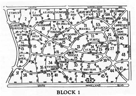 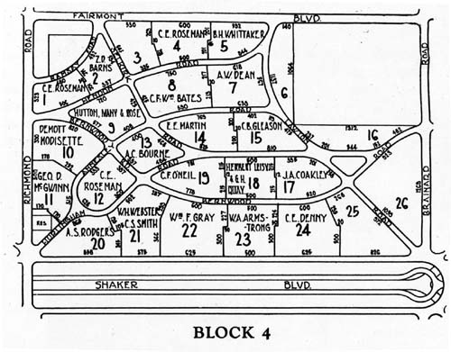 The Vans had expected it to take until 1950 before all of the space would be fully developed. Financing for the road improvements were arranged through the Villages taking out long term improvement bonds. In exchange for the village paying for the improvements and construction of the streets the Vans gave the land for the roads to the communities. Most of the planned streets in Beachwood and Pepper Pike were never put in. In general the streets were not put in until most of a block was sold. The streets that were put in included Bryden, Letchworth, Hurlingham, Hendon and Selkirk in Beachwood and Kersdale, Edgedale, Belgrave, Belcourt and Bolingbrook in Pepper Pike. Two streets that were started and never finished can still be seen today. They are Belcourt and Shenley. They can be found on the west side of Brainard between South Woodland and Chagrin Blvd. While this is now Pepper Pike the unfinished streets would have continued west into Beachwood.  Photo, taken 1960 by the Ohio Department of Transportation. Note the location of undedicated Belcourt and Shenley along with the location of old South Woodland. At times this street was known as South Woodale. You can also see the unpaved and decayed streets in the Beachwoodland Co.'s development. The only Estate-type home built in Beachwood was in Block 4 and, was known as the Bernwood Estates. The home was built for A.C. Bourne. This home has an official address of 2800 Selkirk. A.C. Bourne was a purchasing agent for the Bourne-Fuller Co., which was founded by his older brother. The company manufactured Iron, Steel, Bolts and Nuts.   Bourne Home under construction at 2800 Selkirk Road. Photo taken early 1920's. Courtesy Mr. Cal Bourne. The house was built by Mr. Ben Heining, a trust officer with the Guardian Trust Company, and a deacon of the Fairmount Presbyterian Church. Mr. Heining built several of the fine homes on Shaker Boulevard as a extra curriculum activity. Mr. Heining took the Bournes prior house at 3165 Fairmount as a partial payment of $50,000 against the cost of constructing the new house of $75,000.00. He went bankrupt paying off the contractors of previous jobs and jumped out the window of his office at 6th and Euclid in downtown Cleveland. Ultimately the Bournes lost their home in 1937 and George Gund, the President of Cleveland Trust Bank, bought it from the bank for $37,500.00. Mr. Gund lived in the home for many years. It was in this home, that he raised his six children George III, Agnes, Gordon, Graham, Geoffrey and Louise. One of the Vans major changes or as they would call them "improvements to the area" was the construction of the eastbound and westbound Shaker Blvd. from Coventry Rd. all the way out to the circle they had constructed at Brainard. At the Shaker and Brainard Circle they planned two additional wide parkway-type roads. The first was Gates Mills Blvd. This road was made wide enough with the intention to run their rapid transit line from downtown, up the middle of Shaker Boulevard and then at the Brainard Circle it would head out Gates Mills Blvd. to Mayfield Rd. The second road at the Brainard Circle headed southeast and was a match to Gates Mills Boulevard. It was called Chagrin Falls Parkway. The intention was for this road to cross South Woodland and enter the Lander/Kinsman Circle about where the current B.P. gas station is. It would then continue on the other side of the circle and head out to Chagrin Falls. The only portion of this divided road that was built is in front of the Orange branch of the County Library. To compound the roadway confusion they also made a major change to S. Woodland. The Vans influence and power enabled them to do almost anything they wanted. When the Vans put in the dual Shaker Boulevards they relocated South Woodland just east of Richmond. Prior to the existence of Shaker Blvd. The eastbound and westbound roads consisted of North and South Woodland along with Kinsman. As you can see from the map dated 1874 both North and South Woodland take a jog northeast and then continue east just past Richmond Road. Prior to the Vans, South Woodland took its jog just east of Richmond Rd. through what is now the JCC property, came out about where Agnon School is, and crossed into what is now the median strip between the two Shakers. It then headed due east. Before the Brainard Circle was put in, South Woodland simply continued east on what we now call Shaker Blvd. If one lived between the Brainard Circle and County Line Rd. on South Woodland prior to the Vans' efforts, one would ultimately live on Shaker Boulevard when the double, divided road was put in. There are still signs of the old South Woodland in the center of Brainard Circle. The new South Woodland Rd. heads due east in front of the JCC and it crosses Pine tree and then it continues east again as Route 87 which is a continuation of the very old Kinsman Rd. The old jog north and then through the JCC property to Shaker Blvd. was in existence until the early 60's and known as South Woodale.  Map Showing the Van Sweringens Plans which included Kinsman becoming a divided road as an extension of South Moreland (Van Aken) extending due east along with the planned Chagrin Falls Blvd. The Vans also expected to widen Kinsman into a double road from Warrensville Center Rd. east as a continuation of Van Aken Blvd. which was known as South Moreland Rd. Northfield Rd. also appears to be a double, divided road with a center strip of grass to give the symmetrical Garden City appearance to it, corresponding with the Vans' vision. Kinsman takes a turn south just as it goes over I-271 and then jogs again to the east just after the highway bridge. The Vans planned to have their new double wide parkway replacement road known as South Moreland continue straight instead of taking the jog in the road. If that had been done the road would be about where the parking lot is for the Village Square Shopping Center. Plans called for this road to end at Chagrin Falls Blvd. Just before it entered the Lander circle. They also made one more change that actually caused the creation of Pinetree Rd. Before Lander Circle was put in and the short double wide portion of the road to Chagrin Falls was put in Kinsman simply went straight east on what is now Pinetree Rd. That is why further out into Burton Route 87 is called Kinsman Road. All of the street re-designing was done to allow the Vans the best use of the land for their development of this precious land. The Vans were looking to create the very best community they could. To them that meant the very best country clubs for their wealthy home owners,beautifully landscaped roadways and an assurance that their development would have only white home owners. To insure this the Vans wrote deed restrictions into their contracts. The restrictions not only excluded non-whites but also required a new home owner to get 5 neighbors on each side of the home to approve them as neighbors. It has been speculated that the Vans strict policies were aimed at restricting Catholics and Jews from living in their developments. Interestingly, the Vans had no plans to set aside any land for Catholic Churches or Synagogues. The Vans encountered difficulty in obtaining a company to build their "Shaker Rapid" rail line. The Nickel Plate Railroad was reluctant to allow the Vans' line access to Downtown. The Vans solved the problem by purchasing the Nickel Railroad from New York Central Lines and placing the Vice President of the New York Rail, J.J.Bernet, in charge. Construction began on the line in 1914 and the first section which connected East 34th St. to Shaker Square was opened in 1919. In 1928 the line was extended to Warrensville Center Rd. and the final section to Green Rd. did not open until 1938. The Vans' prime ally was the mayor of Shaker Heights, William Van Aken. The three of them worked together to build the "Garden Community" they desired. Along with enabling easy access to transportation, they also wanted to keep their community "pure" by restricting certain groups of people from living there. In addition to restricting certain religious denominations from living in their developments, they also excluded "Colored" people. The Vans restricted "Coloreds" from living anywhere in the community unless they were servants or maids for the wealthy home owners. Many of the established farmers in the area resisted the Vans' efforts to buy their land because of this prejudicial attitude and practice. The Manx, who had been established in the region for many years, found the Vans' practices in conflict with their own beliefs. The restrictions on how land was used and who could live on the land was done through deed restrictions. They were put in place by the land owners 2E Once the Vans owned the land they would put the restrictions in place with a 99 year time frame. It has been said that the Vans designed roads to go through farmers' property to force them to sell with the help of using eminent domain. However the alleged use of eminent domain is not proven. Eminent domain can not be used by a developer but only by a government when development needs require such action. The Council minutes do not mention any such action. Infact, the reason that Fairmount (North Woodland) does not follow the route of North Woodland through Beachwood is because John Corlett would not sell his land to the Vans for development. Therefore the Vans had to redesign Fairmount to travel east past the current North Woodland and join with Brainard for a short block before rejoining the old route of North Woodland at Brainard. 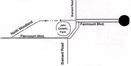 Map shows the original route of North Woodland. John Corlett was unwilling to sell his farmland, so the Vans went around him. His house can still be found on N. Woodland at 27350 N. Woodland. For many of the farmers the Vans' plans brought mixed feelings. Many certainly did not want to sell their land; others saw no choice. They knew that with the new housing developments and rising land values they would not be able to pay the higher taxes on the increased amount of property they owned. Many saw it as an opportunity to sell out as they were aging and their children wanted no part of farming. You might notice that in Beachwood, Pepper Pike and Hunting Valley there are very few Century homes. That is because as soon as the Vans bought a farm they would tear down all of the buildings that existed on the property. While the Vans were building the tracks for the Shaker Rapid they also needed to build the Country Clubs that they had promised in their original promotion of the area. The Vans had investments in four clubs including The Shaker Heights County Club in Shaker Heights, The Pepper Pike Country Club and The Country Club, both in Pepper Pike and the Canterbury Golf Club in Beachwood. Canterbury's driveway resides within Shaker but the majority of the Club is in Beachwood. The east end of the course was reconstructed when Green Rd. was relocated in 1928. The re-location of Green Rd 2E is a perfect example of the Vans' power to get things done. This was a project that was paid for by the County with tax dollars. That is the reason that "Old Green Rd". can still be seen off Halburton and Green. Actually the Beachwood Cemetery (also known as the Warrensville East Cemetery) used to have its entrance on Old Green Rd. Now the entrance is on the "New" Green Rd. Canterbury continues to be one of the premier golf courses in the country and has been the rotating home to many Professional Golf Association Play-Off's, including the Senior Open in 1996. 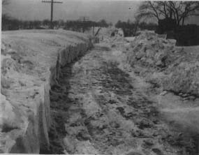 Richmond Rd. looking north between S. Woodland and Shaker Blvd. in 1924. Photo courtesy of Marrion Horvath By the early twenties Beachwood had established itself as a quiet farming community. Beachwood also had a fair amount of income coming in because the state allowed Villages to determine what the tax rate for corporations within their boundaries would pay on intangible assets. Because Beachwood chose to have a very low tax, many corporations listed Beachwood as their headquarters without ever "stepping foot" into the Village. Every January when it was time for the 125 or so Corporations to hold an Annual Meeting, they would post a notice in the Village Hall. On the date of the meeting many of the corporations simply sent a few officials out to the Village and they would meet in the Village Hall's parking lot for a ten minute meeting. It has been said that the official address of these corporations was the 20x 20 square building located at Green and Fairmount until the 1980's. In later years it was the real estate office for the Kangesser development which was located behind the small building. One of these corporations included North American Coal. Many of them were shipping companies that were located in what is now the Huntington Bank Building at East 9th and Euclid in downtown Cleveland. While this law was in effect, Beachwood had a fair amount of money in its bank account and could afford to make street improvements and have a favorable bond rating for improvement bonds. In January of 1926 the Vans announced plans to develop 132 acres they had bought several years earlier on Fairmount that had been the Foote Family's Farm. This land was between the soon to be built "Beechwood School" and the property that Fairmount Temple now resides upon (Hendershot farm). The name of this development was "Fairmount Park Estates". However this development like most of the Vans' plans past Green Rd. would not happen f or many years and would be carried out by another developer. When it did happen, it encompassed most of the Foote farm and portions of the Giesler farm. Fairmount Park Estates evolved to include all the streets from Fairmount to Penshurst and Buckhurst to Richmond. By 1926 there were new names in the Village Council. They were Hendershot, Giesler, Marous, Zink and Rindfleisch. Several of these names would continue for many generations within Beachwood. Ellis Hendershot owned the farm where Fairmount Temple now sits. For the next 30 years Mr. Hendershot would drive the school bus and be the custodian at the new Beechwood School. Many years later the story would be told that when Mr. Hendershot drove the school bus he had a unique way of paying certain young boys back for mis-behaving on the bus. Apparently Mr.Hendershot chewed tobacco. When a young male student would get off the bus and walk in front of the bus to cross the rural street, Mr. Hendershot, would spit his tobacco at the boys boot with an aim for the boys open boot strap. Cora and Ellis Hendershot did not have children however every child in the Village were their children in a very special way. Allen Root who grew up in Beachwood from 1931 until 1946 remembers Mr. Hendershot taking him under his wing and keeping an eye on him as he grew up The land that the Hendershots owned went back as far as Timberlane Dr. It had been owned by Cora's father Walter Lippert. Mr. Lippert also owned the land west of the Hendershot farm to Green Rd. Mr. Lippert sold his land to Kangasser who subsequently developed Fairmount Greens. The Lippert family has ties to the Beachwood Village and Warrensville Township as far back as the 1850's. E.F. Rindfleisch lived on the Park Synagogue cemetery grounds at Richmond Rd. and Kinsman Rd. He was responsible for maintaining the cemetery and coordinating funerals as they occurred. His son Art would take over those responsibilities in later years. While not one of the first, Art would be one of the earlier members to serve on the Beachwood Volunteer Fire Department. 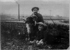 Approx 1935. Mr. Hendershot, 3 year old Allen Root and Laddy.This picture is thought to have been taken at the cornerof Fairmount Blvd. looking south and Edgewood Rd.Photo courtesy of Allen Root. A.C. Giesler was a farmer and long time resident of the Village. A.C. came to the United States at the age of 12 in 1882 at the age of 12 with his parents from Frankfort, Germany. Before moving out east he lived with his parents in a German neighborhood in Cleveland and attended The Spencerian Business College (formerly known as DYKE College) and now known as David N Myers College. After his marriage to Marie Elizabeth Foth in 1893 they lived on Dent Rd. in Cleveland before joining his parents who had moved to a farm on Richmond Rd. in Lyndhurst, across from the Three Villages development. A.C. had worked in a print shop and the lead was starting to impair his health. It was thought that the fresh country air would help him. So, he decided to build a new house in the same area. A.C. and Marie had five children: Carl, Herbert ,Ray, Esther and a son Ernst who had died in infancy. While this farm had 5 acres, A.C. rented 20 more acres down the road in Beachwood from Mr. Bryon Stickles. The land behind them was developed as an estate for the wealthy Henry Sherman family. Mrs. Sherman was the former Edith McBride and sister to the wife of George W. Crile the founder of the Cleveland Clinic. Quoting Esther Giesler "the grounds of the Estate were beautiful". There was a tennis court, ice house, and a home for the grounds keeper. They also needed a chauffeur and A.C.'s young son Herb was ready to take on the job. 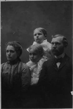 A.C. Giesler, with wife Marie and two of their children,August Carl (T) and William Herbert(L) Photo taken 1900 . Courtesy LesGiesler. In 1911, A.C. decided to sell his home in Lyndhurst and rent a farm and house on Richmond Rd. in Beachwood. The home stood on 100 acres of land. With the boys being older, he had the necessary help he would need to farm all of the land. For the most part he grew strawberries and other fruits. For many years he would be the exclusive grower for the prestigious Chandler and Rudd Grocery store located in Shaker Heights. In 1920, he had the opportunity to buy back the home he had sold in Lyndhurst. He decided to move the home into Beachwood across from the house he had rented. This was no easy project. They prepared a new foundation and then used logs to roll the house around several other farmers' lots and finally placed it on the new foundation. The Giesler home is still standing today at 2478 Richmond Rd. A.C. Giesler died on August 2, 1938 after a life of extensive contribution to the community. He served on council for many years and worked closely with the community to develop the schools. A.C.'s contributions could also be found in his children. For many years his son Herb would serve as the first Marshal. In 1930 Herb and Mayor Clifford Zink owned a popular restaurant known as the Highland Barbecue. It was located on Kinsman west of Green and although it changed ownership hands numerous times, it remained in business until the late sixties. Clifford Zink was also the grounds keeper of the Highland View Golf Course. In the winter months he would move his family to Florida. This is one of the reasons that his children are not in any of the school pictures. Another early resident of the Village was Frank Marous. Frank Marous (pronounce Mar-oosh) was one of six children of Joseph and Lydia. Joseph and Lydia purchased a farm in Beachwood (when it was still a part of Warrensville Township) before the turn of the century. At one time their farm included land on both sides of Richmond Rd. between Shaker Blvd. and South Woodland Rd. The farm house and barns were located on Richmond on land now owned by the Temple Branch. Their farm was a family farm that also supplied dairy products within the community. Frank was a Councilman from 1924 to 1926. He then served as Clerk of Council from 1926 to 1939. In 1939 he was elected Mayor and served until he moved to Geauga County in 1945. Frank and Mae Marous had two children Don and Marian. Frank's sister Mary taught school at the old LaRue school house from 1915 to 1919. 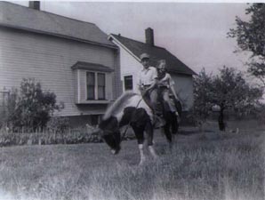 1940, Children of Frank Marous, Donald and Marian Marous taking a casual ride on their family farm located on the east side of Richmond at Shaker Blvd.  Children of Joseph and Lydia Marous. (LtoR) Joe, John, Albert, James, Mary and Frank. Another early settler in the area was George Kerruish. His home is one of the few left in the area at 2270 Richmond. His 39 acre farm would include today Community Drive, Union Circle, Hilltop Dr., Orchard Way and Margot Ct. The Kerruish family were long time residents of Beachwood and members of St. John Church in South Euclid. Across the street from the Kerruish's home lived the Richardsons at 2273 Richmond. Edward and Elise Richardson moved from 68th and Cedar in 1924 so Edward (Bud) could be closer to his work. He was the manager of the locker room at the then new Acacia Country Club in Lyndhurst. The home they lived in and the 265 acres it was on (current site of Beachwood Place Mall) was owned by the country club. Prior to Acacia building its permanent club house in Lyndhurst, the home the Richardsons lived in was used as the meeting place for members of the club. The Richardsons stayed in the home until 1942 when they bought a home in Cleveland. 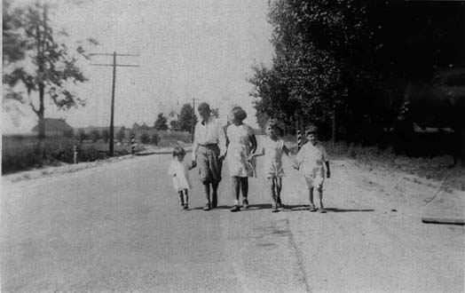 Approx 1931, L to R, Jean Thomson, Tony Richardson, Mary Richardson, Jack Thompson, and cousin David Smith walking south on Richmond Rd. in the area of Hilltop Dr. The Richardsons had two children, Tony and Ruth. Both attended Beachwood's eight room school house on Fairmount. When Ruth attended the third grade there were a total of 12 children in grades one, two and three. For high school, Ruth went to Shaker Heights High School and Tony went to South Euclid's Brush High School. Mrs. Richardson was an avid grower of fruits and vegetables and operated a road side stand. Mr. Richardson worked for the country club for 30 years. One of Ruth Richardson's memories was that of riding the Kerruishs' horse. Walter Kerruish, the son of George became a close friend in the way many neighbors did back in the farming days. Ruth also remembers that from time to time transient workers would pass by looking for work in exchange for food, and of course no one went away hungry from Mrs. Richardson's home. Although it is believed that all of the early residential development in Beachwood was designed by the Vans, there is evidence that there were other developments going on before the Vans rose to prominence. The first signs of a planned housing area were at the northeast corner of Richmond and Kinsman. The streets started to appear on the maps in the early 1900's or from the aerial photo one can see faint signs of the street's existence. It is unknown if any of the streets were paved or how many homes actually existed Early residents of Beachwood do remember a group of African Americans that lived on this land in the 1930's. It is known that Marion Jackson and her brother Clarence and sister Ernestine lived in one of these homes and attended Brush High School in South Euclid. A fourth child, Olivia, was killed at the age of thirteen while walking down Richmond Rd. Marion graduated in 1934 and her brother graduated in 1936. According to Brush alumni members, Marion and her brother were the only non white students in the school and unlike Shaker Heights, skin color was never an issue at the school. Today there are a few signs of these homes in the woods off of Enterprise Dr. 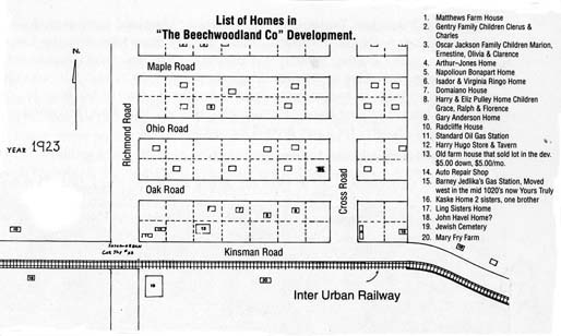 Drawn in 1997 from memory, Mr. Ralph Pulley indicates the homes that existed in this early housing development in 1923 at the northeast corner of Kinsman Rd. and Richmond Rd. Long time Woodmere resident and councilmen Mr. Ralph Pulley remembers that as a child he lived in the development a few years before moving to Woodmere. Mr Pulley also remembers that there was a gas station on the northside of Kinsman just about where the southbound I-271 traffic exits on to Chagrin. This was known as Jedlinka's Gas Station. It was later moved and that site is now Yours Truly Restaurant. The move is thought to have happened in the late 1920's. Ultimately the land was purchased by the Van Sweringens. However, like many of their plans the land sat idle for decades. There were two early 1920's housing developments in Beachwood that did be come reality. However while they were started before the depression and it would take many years after that for them to develop into neighborhoods  The first was approved in September of 1925 when council approved the Plat map that laid out the streets of the Rapid Land Transit Company's development of the Cedar and Green area. These streets would include Fenway, Campus, Cedarview, East Baintree, East Silsby, East Groveland, Lyndway, Glenhill, Edgehill, Woodway and Halcyon. While it is thought that the Vans owned the Rapid Land Transit Company, they did not. It was a land development company that was affiliated with the Ford Realty & Mortgage Company,which was located at 2409 Euclid Ave. This same company developed many of the streets in Cleveland Heights and University Heights in the early 1920's. This project included 262 lots. While some were larger most lots were 55 feet wide by 130 feet deep. The land had been owned for decades by Roselia Foote and John Radcliffe. Both of these family names go back to the early settlers of Warrensville Township. These names can be found in the Beachwood Cemetery at Green and Halburton Rds. Due to the depression only six homes were built before the country went bust. After these six homes were built, new home construction in the development would not start up again untill the early 1940's One of the first homes to be built in the development was that of Stanley Walker. The Walkers moved into their new home at 23500 East Baintree in 1929. They moved to Shaker Heights in 1942. Mr. Walker was a member of the Village Council for several years. One of the issues that he is most remembered for were his thoughts on building tennis courts during the depression. In the mid 1930's the WPA was offering communities help with a wide variety of projects. At that time Beachwood did not need much from the WPA and Mr. Walker insisted on having something done other than fixing a few roads and cleaning up the cemetery. He was able to have two tennis courts built on the northwest side of the Beechwood School. These courts were the very best one could have. However, there were very few people who used them. Simply put, there were very few people that lived in Beachwood at that time. Mr. Walker's daughter Dorthea, who now lives in Maryland remembers, having only a few friends in the neighborhood, simply because there were very few homes in the neighborhood. Dorthea was the only student in all of Beachwood to attend the second grade in 1936. One of the nice things about living on a street with no other homes was the ability to keep a horse in one's backyard. One of her favorite past times was to have her friend Nancy Thomas who lived at 23601 East Groveland join her on her pony "Fanny" for a ride around the neighborhood. The other five homes that were located on East Groveland. They were: 23304 East Groveland. Built in 1929 for Julius and Susan Nagy. In 1935 it was owned by Ed Havel. Mr Havel was a detective with the Shaker Heights Police Department and the brother of Beachwood Police Chief John Havel. 23600 East Groveland Built in 1929 for Charles and Maud Thomas. Mr. Thomas was an Architect. His father built the home and the one across the street at 23601. They had one child named Muriel. Mr. Thomas was the architect that had designed the Society for Metals building on Route 87 near Punderson State Park. 23601 East Groveland Built in 1929 for Ronald and Katherine Burnham. Home to Richard and Annette Burney from 1944 until 1993. the Burneys had three children. Mary, Jon and Richard. 23606 East Groveland Built in 1929 for Walter and Dorthea Thomas. Walter was a dentist and a brother to Charles across the street. They had one child named Nancy 23609 East Groveland Built in 1929 for Herbert & Marjorie Swallow. 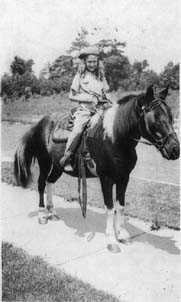 Dorthea Walker riding her horse "Fanny" on the sidewalks of East Baintree.  Stanley and Dorthea Walker with "Fanny" in front of their home at 23500 East Baintree. Photos were taken in 1935. Photo courtesy of Dorthea Dressler. The second development was at Green Rd. and Fairmount Blvd. The streets in this development include Ranch, (which at the time was named "Meadowbrook"), Larchmont, Elmhurst, Fernwood, Brentwood and Edgewood. This development was presented to council in September of 1926 by the H.A.Kangesser Co. This land had also been owned for many years by early settlers of Warrensville Township. Some of it was owned by Walter and George Lippert. Cora Lippert, the daughter of George Lippert married Ellis Hendershot who is mentioned earlier in this book. Beachwood had three other early 1920's era planned developments that looked good on paper, however, for a variety of reasons did not get close to completion. They were: L.H. Heisters development of Greenlawn, Isabelle, and E. Scarborough.These roads that would run from Green Rd. east to Richmond Rd. Only portions of these streets were put in and the portions of the roads put in were not developed until the early 1960's. E. H. Matthew's Auto Villa's Sub Division. This development never happened. Located on the south side of old North Woodland Rd., just east of Richmond Rd. This development consisted of 12 lots on 10 acres of land. It is interesting to note that Hopkins Maps from the 1920's indicate a Russian Orthodox Cemetery on a portion of this property. This would be around the 26200 block of North Woodland Rd.
The Glen Park Co.'s development of Ramsey Rd. This development called for two streets along with Ramsey to be built on the northeast corner of Richmond Rd. and Fairmount Blvd. For many years the only street put in was Ramsey. One of Beachwood's newest streets, (1990 era) Meadoway Dr. was the second street from the original plan to be built. The third street that was never built was Glen Park Dr. which would have started at Ramsey and Richmond and headed East to Meadoway. Today the land this street would have been built on is part of the "The Village" development. In December of 1926, the people living on Helen Rd.(then located in Beachwood) petitioned for annexation to the Village of Shaker Heights. It was the feeling of council that this should be allowed only because the issue was threatening the peace and order of the community. At the same time the Village realized that they needed to establish a Charter for the village because annexation of land from the village needed to be discouraged and controlled. In 1928 Beachwood opened its modern eight room school. This allowed the Beachwood School System to close the older school houses that it had acquired from the Township in 1915. The new school had a gym in the basement and a stage along the back of the second floor. The architect building was Beachwood's own Arthur Barber, who lived for many years at 2463 Green Rd. One of the reasons for the construction of the school house was the unpredictable and changing attitude of the Shaker School System, under the influence of the Vans, towards Beachwood's students. Earlier in the fall of 1925 the Heights Press reported that "Beachwood May Build School For Children Refused By Shaker" The article read as follows: School Authorities of Shaker Village have refused to accept twelve colored children from Beachwood Village for education in the Shaker Heights Schools. Mayor W.J. Van Aken stated he understood Beechwood will take care of the children by creating a separate school district and building its own school building. Shaker has been accepting children under contract whereby Beachwood pays a fixed sum for the educational service. The situation was handled swiftly by the Beachwood Board of Education. They went to the County Prosecutor and filed a law suit against the Shaker School System on October 26, 1925. The Cuyahoga Court of Common Pleas found in favor of Beachwood and ordered Shaker to educate all the students under the contract. The also ordered Shaker to pay all of the costs Beachwood had incurred due to the case. The case number was 249672. With a new school house the board of education was able to sell the village the LaRue school house property at the northwest corner of Fairmount Blvd. and Richmond Rd. The land not only consisted of the old one room brick school house, it also had a fairly new temporary structure behind the old school house. This building was a built in 1926 as a temporary classroom building in anticipation of a lengthy legal battle with Shaker Heights over the use of their schools for "Colored" Students. With this issue resolved and the completing of the new eight room building to the west, both of these structures were no longer needed. The village purchased the land from the school system and started to use the temporary classroom building as their official Village Hall. In August of 1928, Mayor Corlett, announced that the old Lewis school house needed to be torn down and the new Village Hall moved up into its present location. Apparently many of the villagers did not like the long trek in the mud to get to the new hall. An offer was put out in the village to anyone who wanted the bricks from the old school. The offer stipulated the taker to dismantle the building and take the bricks with them. The Clerk of Council Frank Marous said "we will never find anyone who wants the bricks," however Mayor Corlett was a bit more optimistic. A friendly wager was made. The loser of the bet would have to buy the city council members a chicken dinner. Several days after the notice was put out a village resident by the name of Charles Vajner said he would take them. The building was so old that he wanted the bricks because they were handmade and valuable. The Village Hall was then moved forward (south) to its presentlocation, and a basement was finally dug out. This in now the home of the Beachwood Arts Council. In 1929, Beachwood made the newspapers when Thomas Leigh, a Deputy Marshal in the Village, was involved in an automobile accident while on duty driving friends in the village's new police cruiser so they could catch the last street car. The accident took place on Green Rd. near Cedar Rd. The two close friends in the car died instantly and Leigh who was thrown from the car recovered from his internal injuries at Mt. Sinai Hospital. Leigh had been a member of the police force for only 10 days when this tragic event occurred. According to the Township map of 1903 there was a large farming parcel of land on the northwest corner of Richmond and South Woodland Rd. that the Leighs farmed. For many years the Leigh family operated a slaughter house in the rear of the house. Most of this land was sold in 1925 to the Euclid Arcade Building Company. A small portion was kept by the Leigh family that fronts South Woodland. The home is still standing and is three houses from Richmond Rd. at 25361 South Woodland. The Leigh family sold the home early 60's. 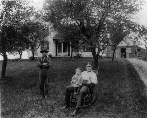 (L to R) J Kall, a hired hand, Anna Leigh in the lap of her uncle Clarence Leigh . The home was built in 1877. The photo was taken 1915. The home was built by Thomas Box Leigh. Young Anna Leigh's brother was the Beachwood police officer injured in an accident. in 1929. If you drive by this home today at 25361 South Woodland, you can see the crest in the drive to be about the same as it was in 1915. The village leaders also had to confront an issue created by new technology. Apparently an airport was built on land next to the new school on Fairmount. This became a problem because the students in the school were distracted by the noise and enjoyed watching the planes take off. Due to the problem Mayor Corlett introduced legislation and Police Marshal Carl Behm was instructed to see that the law was enforced, and the airport was closed. In December of 1929 construction started on the Green Rd. and Richmond Rd. bridges that would span the anticipated Shaker Rapid tracks. There have been many attempts to extend the Rapid out past its current Green Rd. termination point but that has never happened. In fact in the late 1980's it was decided to remove the decaying Richmond Road bridge and there was really no reason to replace it, since there were no train tracks below it 2E The year 1929 ended with Elmer .J. Corlett as the Mayor and dairy farmer Frank C. Marous serving as the Clerk of Council. The council was comprised of C.J Zink, A.C. Giesler (who served for 18 years on council) his son Herbert Giesler, V. Hlavin E. Hendershot, and W. Matthews. Two long time residents and contributors to the community, E. Rindfleisch and F. Eickoff would join the council in 1930 and serve for many years to come. Many of the Van Sweringens' plans were initiated in the late 1920's. Beachwood, like Shaker, was well on its way to becoming a planned community. New streets were being put in and improvements were happening all over the Village. The Shaker Rapid was anticipating expansion to Brainard and to much of Pepper Pike which was also gearing up for the Vans' big plans. However, by 1930 the depression that would cause the Vans and many others to file bankruptcy would impact the anticipated improvements for years to come. While the depression hit in 1929, the Vans did not totally fall apart financially until 1933. However, the Village was already feeling the pinch by mid 1930. Salaries were cut and little could be done in the way of furthering the planned improvements to the Village. There were also fewer and fewer farmers in the area. Most of the farmers who sold their land to the Vans also ended up in a financial disaster. The Vans paid a farmer 25% of the sale price in cash. The balance was paid with either stock in their company, or in a mortgage note or promissory note at 6%. Very few people were paid cash for their land. The Vans were paying a fair and respectable price for the land at up to $2000.00 per acre. On Oct. 23, 1930 the Vans were summoned to New York to meet with their bankers to discuss the problems that they faced. Much of the Vans' collateral was in stock of other companies including the Allegheny Corporation. For the most part the value of those companies slipped well below an acceptable comfort level for their bankers. The Vans were able to restructure their loans in the amount of 48 million dollars with J.P Morgan. The maturity date was May 1, 1935. While this provided some relief to the Vans,their main concern was not the development of Beachwood but the survival of their railroad empire. Prior to the crash of the stock market the Vans owned a 3 billion dollar railroad empire with 30,000 miles of railroad tracks. Those farmers who did not sell their farms were not insulated from the financial woes of the depression. Many of them took an interesting precaution to avoid total devastation of their assets. They had the property divided into two parcels; one small one with their house on it, and the other parcel with farm land. If they could not pay all of the taxes on their property they would be sure they paid the taxes on the small parcel with the house on it, and let the farm land become delinquent in its taxes. This was a smart move, because with times being as tough as they were, they did not have to worry about the County taking their land for the past due taxes. There was little risk of someone else buying the land, because there were few people around interested in buying farm land without a house or barn on it in the middle of the depression. In October of 1930 Ray Giesler became part time Deputy of the Village. His brother Herbert would be the first Chief of Police. Herb served for over 20 years and continued to live in Beachwood and like his father A.C. Giesler, would contribute to the development of the community for many years. Herb died in 1971. In 1932 the Village solicitor demanded a retraction from the Cleveland Automobile Club, for making the statement on WHK radio that, "Deputy Marshals with a tin badge are hiding in the bushes on the outskirts of greater Cleveland like a pack of hungry vultures seeking whom they can devour". The spokesman for the Auto Club, Fred H. Caley further stated that "The villages and cities whose officials are exercising pernicious activity in this direction are Garfield Heights, Beachwood, Willowick and Orange Townships." 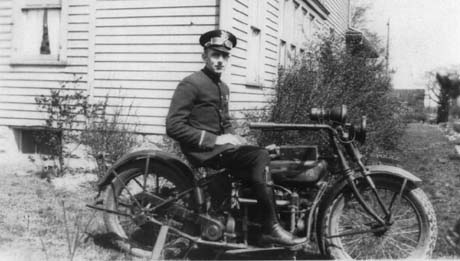 Beachwood's first Police Chief, Herb Giesler sitting on the village motorcycle behind his family home at 2478 Richmond Road Circa 1925. While Beachwood was making the newspaper because of the WHK interview it had much more important issues to address at the village hall. The village was running out of money. The depression had a devastating effect on its major developer and its financial problems were compounded by the small number of land owners who could not afford to pay their taxes to the county and the village. In addition, state laws were changed to prohibit corporations not located in Beachwood from using the Village as their corporate address. These corporations were trying to gain tax breaks and the leaders attempted to meet with the Vans regarding the problem but they did not receive any satisfactory answers. The Vans problems were complex and by this time their concerns were not in land development but rather in keeping the many railroads that they owned going. Beachwood would again make the headlines on Dec. 30th 1932 when the body of Mrs. Ruth Gilmore Steese was found on the westbound side of Shaker Blvd. 1000 feet east of Richmond Rd. Mrs. Steese worked for the Cleveland Society for the Blind and had stopped to cash a check for $191.25 at a bank on East 57th. She was then found 45 minutes later dead in her car in Beachwood Within a few weeks there were only a few clues that ultimately lead to the arrest of Peter D. Treadway, who had served already 8 years for a prior murder and two years for robbery. Treadway was sentenced to death and attempted to appeal for a stay of execution from Governor Martin L. Davey. His appeal was rejected and he was executed in the electric chair on June 2nd 1935 at the Ohio Penitentiary. Life in Beachwood during the depression was not as hard on its residents as it was on those living in Cleveland according to Esther Giesler Curtiss. She remembers that as a child growing up that Beachwood's farmers did not have it as tough as others because they were used to being poor and living on a meager farmers income. While there was little to do for recreation, and their was no money to spend, life centered around the eight room school house and the church at Fairmount Blvd. and Richmond Rd. On a regular basis the school would put on community plays and the church would hold pot luck dinner on Sundays. While they were held at the church, being a member of the church was not necessary. 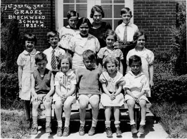 Beechwood's 1st, 2nd and 3rd. graders in 1835. Photo courtesy of James Fisher. By 1934 Beachwood's land owners owed $610,000.00 worth of delinquent taxes. The village leaders realized it needed to do something and asked the county to reapportion the taxes owed over the next 15 years. What the Village leaders had no way to project was how Beachwood's economy would prosper in order to permit the land owners to pay taxes in the coming years. At the same time the bond holders were looking for ways to have the county issue a levy against the land owners for the debt owed. The March 15th 1935 edition of the Heights Press, a Cleveland Heights - based newspaper reported that Beachwood could not pay its April payment of $40,000.00 to its bond holders because the total tax collection did not generate enough revenue to pay the annual interest installment. By 1935 the outlook in Beachwood was quite bleak. The Vans were also nearing the end of their company's existence. The end of the Vans' empire was near. Not only would their company file for bankruptcy, they would both die within one year of filing.. On May 1, 1935 they notified J. P. Morgan that they would not be able to meet their loan obligations. By September their collateral was auctioned off to the Mid-America Corporation. Mr. George A. Ball, "The Ball Jar King" and George Tomlinson, a Great Lakes ship builder and banker, were the founders of the company and bought the collateral for the sole purpose of turning it back over to the Vans. Ball and Tomlinson felt the Vans had run a super growth organization, and if the Vans were allowed to continue to run the empire it would continue to grow as the economy recovered. The collateral included stock and notes in 11 holding companies including the valuable Allegheny Corporation. The solutions to the Vans' problems would soon be on the shoulders of only one of the Vans. In August of 1935 M.J. entered Lakeside Hospital suffering from high blood pressure and influenza. He died of heart disease on Dec. 12th of that year, at the young age of 54. His funeral was held at their home at Daisy Hill. The surviving brother, Oris would not see much more success because the Missouri Pacific Railroad filed a complaint with the Interstate Commerce Commission. The Missouri Pacific was a small line owned by the Vans which had filed for bankruptcy in 1933. The complaint initiated an investigation into Mid-America's control and led to the Van Sweringen Companies declaring bankruptcy in February of 1936. On November 22, 1936 a private car of the Nickel Plate Railroad left the Cleveland Union Terminal with O.P Van Sweringen for a business trip to New York City. O.P. felt tired and as the train was pulling into Hoboken, New Jersey his trusted companion, William H. Wennenman, found him dead of an apparent heart attack at the age of 57. The two Van Sweringen brothers are now buried in Cleveland's LakeView Cemetery. For the next 20 years foundations, trusts and newly formed Corporations would control the assets, stocks and deed restrictions that had once belonged to these two legendary men. Beachwood's financial problems had not improved by 1936. Population was l ow, 237, and the whole country looked to President Franklin D. Roosevelt to improve the situation. In an effort to put people back to work and, as a overall recovery effort he created the Works Progress Administration (WPA). The east side of Cleveland had more than thirty projects. Two of the larger projects included the construction of a new Mayfield Rd. through Gates Mills, and the extension of Monticello Rd. from Cleveland Heights to Green Rd. Beachwood's projects included construction of sidewalks on Rexway and Stratton and grading and landscaping work at the Beachwood Cemetery located at Green and Halburton Rds. The project was limited in scope and the problems which existed were far reaching. Many of the streets that had been put in by the Vans were starting to deteriorate. Roads such as Bryden, Letchworth, Hurlingham and Hendon were not constructed from brick, but with a combination of cinders and asphalt known as macadam. The problem with this type of surface is that if it is not treated with oil from time to time, it will decay. With no one living on these streets except the Bournes (later the Gunds) residence on Selkirk, the roads fell into disrepair. At one point the financial picture was so bleak that the street lights the village had were turned off because their were no funds to pay the electric bill for such a luxury. 1936 also brought a bit of light into Beachwood. That was when Mrs. Dudle y Blossom decided to develop land she owned at the southwest corner of Cedar and Richmond Rds. Mrs. Blossom and her family lived across Cedar in Lyndhurst. Her original intention for the land was to provide a place for her children to build their homes when they returned to the area after finishing college. However the children decided not to return to the area. One of the first families to build in the development was the Chilcote Family. Mr. Lee Chilcote was the owner of The Chilcote Company and the Brewer Chilcote Paper Co. It has been said that Mr. Chilcote was the one who convinced Mrs. Blossom to divide up the parcel of land and spend the dollars necessary for the construction of the two roads, Community Dr. and Union Circle. Mr. Chilcote also served as a councilman from 1941 until 1950. Other original and prestigious families that lived in that development included: Fisher, Cronin, Judd, Pope, Hanger, Gale, Albrecht, Linderme, Shephard, Bolton, Mangine, Crofot, Prayton, Harrison, Selover and Pile. Many of the heads of these families were doctors and well established business owners within the community. One name that served not only the community of Beachwood in a very special way (see chapter 4) but also served all of metropolitan Cleveland was Larry Pile. Mr Pile along with his three brothers ,was the 2nd generation owner of the Hough Bakeries. This bakery had been started by his father Lionel Pile. Anyone who lived in the area from 1903 until August of 1992 can remember visiting one of the 32 Hough Bakeries for their great birthday cakes and fresh pastries. Lanore Linderme Kaplan and Martin Pope remember growing up on Community Drive and having the feeling of living in a quaint little community that was well protected under the watchful eye of former Police Chiefs Havel and Sexton. Both LaNore and Martin remember the thursday evening barbecues that took place every week in the park area of the development. Martin also remembers riding bicycles up Cedar Road. which was then a two lane brick road and having a pop at Sextons gas station which was located at the northwest corner of Cedar and Green Roads. Mrs. Blossom was the daughter of Charles W. Bingham who was one of the pioneers of John D. Rockefeller's Standard Oil Co. Her husband, Dudley Blossom, was the Director of Welfare for the City of Cleveland. For many years these two streets ( Community Drive and Union Circle) were private streets and the village was not required to maintain them. A portion of the land includes a park-like setting on the north side of Community Drive. Deed restrictions were put in place for 25 years. This development would be the only new development in the village until the end of World War II. One part of Mrs. Blossom's Community Drive development is the building known as "The Hanger" This building was first built by Mrs. Blossom in the late 1930's and her friend as a recreation facility for the family. After W.W.II the building became a private swim and tennis club. In November of 1936 the village leaders invited delinquent land owners to meet and again discuss a means to pay the back taxes they owed. Beachwood now owed more than 1.5 million in bonds that had received no principal payment since 1932. Beachwood was not alone with their tax collection problems, but clearly they were the worst among east side suburbs with 85% of the land owners being delinquent. The village wanted to restructure the bonds. However, they would have to pay no less than 50% of the $200,000 2E00 in back interest before a restructuring could occur. The village leadership was hopeful that the large land owners would be able to help contribute to the back interest amount, so the restructure could happen. Unfortunately the Van Sweringen Companies were unable to help. By 1936 the Van Sweringen company was in the process of a total reorganization. In December of 1936 Marshal John Havel submitted his resignation as an elected official. Apparently he was the Elected Marshal which made him automatically the Chief of Police. According to the State of Ohio this was a violation of law. Several years later a Charter amendment was passed eliminating the outdated elected position of marshal. In 1936 there were only two full time law enforcement officers and several part time officers. The two full time men where John Havel and Herb Giesler.
| ||||||||||||||||||||||||||||||
The year 1937 started out with a bit of hope concerning Beachwood's tax collection problem. With over 400 individual land owners, a new law known as the Whittmore law was passed by the State legislature. This law would allow back taxes to be paid on an installment basis. Council urged the Village Clerk, Frank Marous, to write the owners, explaining the new law. Councilman Stanley Walker urged the notification of all delinquent owners because the Village needed to know who wanted to work out a plan, and who was not interested. This would allow the Village to ask the County treasurer, John J, Boyle, to sell the property of those unwilling to work out a plan, and allow the proceeds to go towards the back taxes. The village also received some good news from the Van Sweringen Company. George Arnold, the companys Vice President announced that they would allow the lots in the Shaker Country Estates to be split up into smaller lots to allow moderate income families to purchase land and build homes in the area. The decision was made by Frank F. Kolbe and Robert R Young, who were New York bankers that had acquired control of portions of the Van Sweringen Empire. This move, known as the Re-subdivision of lots, was the first move that allowed homes to be built in Beachwood that would be affordable to a wider market, less exclusive than the Vans had originally intended. While these Re-subdivides were presented with good intention, they would not become a reality until the early to mid forties, when the economy would start to prosper and the demand for housing started to climb. This move also affected a good portion of land in Pepper Pike and parts of Shaker Heights that were east of Warrensville Rd. The year 1937 also brought one more WPA project to Beachwood. Cedar Rd. was widened from Warrensville Center Rd. in University Heights to Richmond Rd. in Beachwood. The width would go from 18 feet wide to 24 feet wide. That year 1937 ended with Mayor C.J. Zink running unopposed along with Clerk Frank Marous, Treasurer Ruth V. Behm and the six incumbent councilmen consisting of J. Anderson, A.C. Giesler, W.D. Thomas, W. Cowle, W.A. Carren and H. Eickhoff. 1938 was the first of many years in which Beachwood School's would be in turmoil. In July of 1938 the school board decided to look into annexation of their schools into the Shaker Heights School System. Beachwood's annual budget for educating their 45 students was $11,000.00 and they were having trouble meeting their obligations. The tax rate was 5.25 mills and Shaker Heights was 14.70 mills. The concern was that the State would force the schools to join another system and they might have to join a less desirable system than Shaker's. After a long debate it was decided to keep the Beachwood System intact. There was a decision to allow the 12 high school students to chose between going to Brush or Shaker. However, the students that chose Shaker would have to pay the difference in tuition and would have to furnish their own transportation. Beachwood would continue to bus students to Brush. Through the years the high school students would attend classes at Orange, Brush in Lyndhurst, Shaker Heights High or Cleveland Heights High School. In 1938 Mayor Zink decided to take on the Ohio National Guard. Apparently the guard had been using Beachwood's farm land for maneuvers. The guard provided the community natural fire works as an attribute of the maneuvers. While the council was in favor, Mayor Zink said no way. His concern was the effect on traffic and that the noise had been scaring away the quail and other game from the woods. The guard prevailed and continued their training. 1939 brought little good news to Beachwood as the decade came to a close. Beachwood would feel growing pains as a small farming village. The next ten years would be quiet transitional years until the baby boomers came to town and changed the look and finances of Beachwood. | ||||||||||||||||||||||||||||||


