|
FIRST MAPS OF CLEVELAND AND THE WESTERN RESERVE
In 1786, Connecticut relinquished all claim to western lands to the fledgling U.S. federal government, except for a 120-mile strip along the south shore of Lake Erie, which was being "reserved"as compensation for land lost to Pennsylvania in the Wyoming valley of the Susquehanna River. This land became known (in various forms) as the "Connecticut Western Reserve" and Connecticut began trying to sell it to raise money for the state's school system. A group of investors purchased the Western Reserve, incorporated themselves as the Connecticut Land Company, and set about preparing to survey the lands and lay out the village that became Cleveland. Like the lands west of the Appalachian Mountains generally, the Western Reserve was little-known, but becoming an important part of the westward movement of settlers in the years following American independence. Maps were crucial to inform settlers about the frontier lands and to attract them to move there. Here are some of the first maps depicting the Western Reserve and Cleveland.
Many of these maps are owned by the Western Reserver Historical Society may be seen on a color microfilm in the WRHS Library.
SOUTHERN SHORE OF LAKE ERIE
First maps of northern Ohio and the south shore of Lake Erie, before the Western Reserve:
- David Brose's article Explorations in the Encyclopedia of Cleveland History covers this period and it's maps well.
- Also see Thomas H. Smith's 1977 book The Mapping of Ohio. (Kent State University Press)
THE WESTERN RESERVE
First manuscript maps to show the Western Reserve:
- Holland Land Company map of 1795. - This is a map produced for the owners of the Holland Land Company, in Amsterdam, who then owned a huge tract in upstate New York. They were interested in purchasing the Connecticut Western Reserve and dispatched one of their American surveyors, Ellicott, who produced this map. The map offers little more than an overview of the Reserve's outline, the Cuyahoga River and some generic fill about forests, but it predates anything produced by the Connecticut Land Company, who eventually did purchase the Reserve. The original manuscript map is in Amesterdam, but the SUNY/Fredonia made a 2/3 color copy of the map and has offered reprints for sale. Check the Western Reserve Historical Society gift shop, too.
- John Heckewelder's map of 1796. - John Heckewelder was a Moravian missionary to the tribes living along the Tuscarwaras River. He was captured by other indians and moved to Detroit. He eventually returned and years later, in 1796, produced this map of the Reserve, which was found amongst Moses Cleaveland's papers after his death. It is particularly important for showing the trails across the Reserve, but it is not known whether Moses Cleaveland possessed this map before coming to the Reserve in 1796. A booklet was published about this map, containing a reproduction of the map and a modern counterpart map by James A. Bier. Copies of the booklet and the map have been available in past years at the WRHS gift shop and the booklet might be found in local libraries.
|
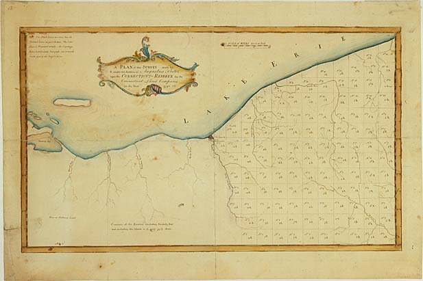
- Seth Pease's "A map of the Connecticut Western Reserve from actual survey." [basis for printed map, below]
First printed maps of the Western Reserve:
- Seth Pease's "A map of the Connecticut Western Reserve from actual survey." (1798) [based on mss. map, above] - This is a map issued in two halves, with the left-hand sheet covering the Western Reserve west of the Cuyahoga River and the right-hand sheet covering the river and lands east to the Pennsylvania border. The two sheets were designed to be joined together, as there are no borders on the common edges, but the map is currently found both as a single, joined sheet and as two, unjoined sheets. The western sheet shows these lands unsurveyed, as the lands west of the Cuyahoga were not open for settlement in 1796, and the eastern sheet shows the lands surveyed into the five-mile-square townships. This is considered "State 1" of each sheet. The western sheet carries the map's title information and the eastern sheet carries the publication line.
- Seth Pease and Abraham Tappan's "A map of the Connecticut Western Reserve from actual survey." (1807/08) - This is Pease's 1796 map, as updated with Abraham Tappan's information. There are two versions, or "States" of each of the two sheets, representing successive updates. In the west, "State 2" shows the lands between the Cuyahoga and the Firelands to be surveyed, but not the Firelands, whereas "State 3" shows the Firelands surveyed, as well. In the eastern sheet, "State 2" shows many of the townships have been named and "State 3" adds one more township name: "Canfield." No updating was done to the publication line, allowing for confusion in when only the eastern sheet is seen. Note that sheets of different "States" may be found joined together. A joined (two-sheet) Pease & Tappan map sold at auction in the mid-1990s for $3,500.
First maps of the "Fire Lands" in the western part of the Reserve:
- Almon Ruggles' "Map of the Fire Lands from actual survey." (1808)
CLEVELAND
BEFORE CLEVELAND
De Lery's Sketch of the Mouth of the Cuyahoga (1754)
First manuscript maps to show Cleveland (although the copies shown here are NOT the manuscript versions):
First view of Cleveland on a printed map (fanciful representation):
First printed map showing accurate details of Cleveland:
Discussions of the first maps of Cleveland:
BACK to the Cleveland Cartography home page
Latest update October 16, 2007
ã Copyright 1996-2007 by William C. Barrow
|