|
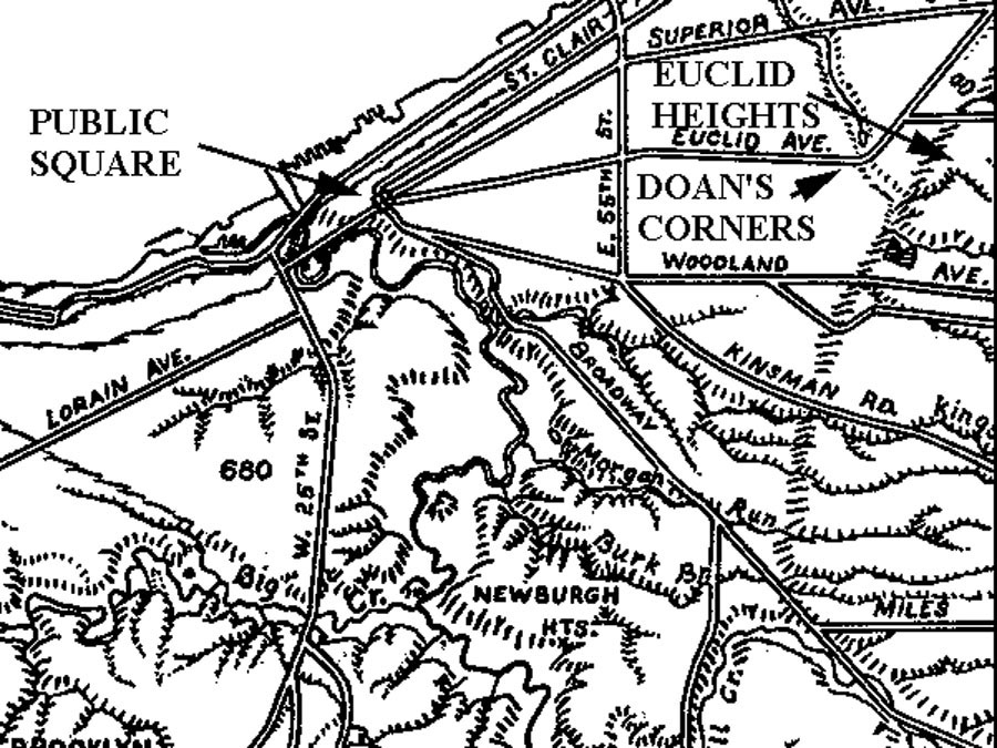
CHAPTER I: INTRODUCTION The Euclid Heights Allotment was a planned community created in the 1890s on the heights overlooking Euclid Avenue where it crosses Doan's Brook, today known as the University Circle area. It was designed to be the finest new residential community in Cleveland's burgeoning East End, and attract the social and business elite of Cleveland, then migrating eastward from the central city seeking rural amenities, urban services and secure property values.
The developers of this property were careful to create a modern suburban product that offered clean air and water, splendid vistas, paved streets, and a private country club, all nestled in a protective cocoon of deed restrictions, public parks and private institutions, and connected by fast, new electric streetcars to the central business district. This was Cleveland's finest example of the streetcar suburbs being constructed around America's major cities in the 1890s, and it survives today as a lovely historical neighborhood in the City of Cleveland Heights. The developers, however, did not fare as well. When the project failed to meet its financial commitments and went bankrupt just before World War I, the principal developer suffered financially. He and his associates suffered other personal misfortunes as well. But Euclid Heights opened the heights for development, and was a harbinger for the nationally renown Shaker Heights community, which successfully employed most of the planning principles instituted locally by the Euclid Heights Allotment. Just as the real estate history of the heights did not end with the Euclid Heights Allotment, neither did it begin there. Euclid Heights was the successor to a century of land speculation and development on the general site called Euclid Heights and needs to be understood in that context. The history of land development on Euclid Heights is linked to events all during the nineteenth century at Doan's Corners and, ultimately, to the wider pattern of growth in Cleveland and northern Ohio. As the century progressed, the relationship between Cleveland, Doan's Corners and Euclid Heights changed and men attempted to create real estate values and profits from the opportunities presented by these changing relationships. Palimpsest DefinitionThis paper will trace the various attempts to create real estate values at Euclid Heights using the notion of a "cartographic palimpsest." The American Heritage Dictionary defines a palimpsest as: A written document, typically on vellum or parchment, that has been written upon several times, often with remnants of earlier, imperfectly erased writing still visible, remnants of this kind being a major source for the recovery of lost literary works of classical antiquity.(1) Here the idea of a palimpsest will be applied to the sequence of maps depicting the property lines and transportation routes in and around Euclid Heights throughout the nineteenth century, in an attempt to "recover" the record of land speculation and development. As Cleveland grew and drew Doan's Corners ever closer into its sphere of economic influence, the cadastral (property ownership) maps of Euclid Heights show different ownership and land use patterns that reflected the opportunities then perceived to be present on the heights. The maps from each era show that the efforts of previous owners have been partially removed and new patterns applied to the site, cumulating at the end of the century with the Euclid Heights Allotment in its various phases. This layered cartographic record, then, is the "palimpsest" that will be employed to demonstrate how nineteenth century men attempted to build real estate values on Euclid Heights, as well as a way of examining the general history of Cleveland. Euclid Heights is the westerly edge of the Portage Escarpment of the Appalachian Plateau, which rises along a northeast-southwest line, just east of Doan's Corners. There Euclid Avenue deflects 45 degrees from its eastward course to run parallel with the edge of the plateau for many miles. The ridge is some 120 feet above Euclid Avenue at Doan's Corners and is cut by numerous streams flowing north to the lake. One of these streams is Doan's Brook, the course of which is now located in a series of lovely parks spilling down from the heights: Shaker, Ambler, Wade, Rockefeller and Gordon. Another stream is Blue Springs Creek, which carved the valley up through which Cedar Glenn Road would run to reach the high ground on the heights. From there, at the crest of Cedar Glenn Road, the site momentarily flattened out before rising another 50 feet to the south and east. The farmers and land developers during the earlier period of Euclid Heights history found the level portions of the site to be most important. At the end of the nineteen century, however, developers of the elite Euclid Heights Allotment determined that the prime parcels were those found along ridges. Responding to a demand for scenic views and elevated terrain, they placed an emphasis upon those tracts having the best views of Cleveland and Lake Erie: those tracts located along the main ridge at the allotment's western edge and at the top of the southeastern rise. These changes in perception of what was valuable land are reflected in the palimpsest. Like the Western Reserve in general, Euclid Heights was originally heavily forested. Despite reported extensive clearing in its flatter eastern areas, the site still retained stands of trees in several places until the end of the nineteenth century. Locals referred to the heights overlooking Euclid Avenue by other names than Euclid Heights, including "Turkey Ridge" for the plentiful wild fowls in early days, and "Heathen Ridge," probably for the periodic encampments of Gypsies in the area. Native Americans undoubtedly traveled the area at one time, but by the nineteenth century played no significant role in the life of the area.(2) At the start of the nineteenth century -- stretched a few years here to encompass the founding of Cleveland and the surveying of the Reserve in 1796 -- Euclid Heights was devoid of boundary lines and the only man-made cartographic feature of interest to this study was the route of the overland trail, now Euclid Avenue. The Euclid Heights palimpsest begins here, as the Connecticut Land Company brings the concept of boundary lines to the Reserve.
NEXT: Chapter II ã Copyright by William C. Barrow 1997 - All Rights Reserved BACK to thesis home page Last updated January 1, 1998
|