|
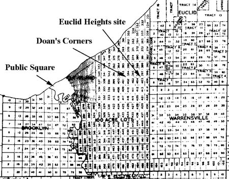
PREVIOUS: Chapter I CHAPTER II: ORIGINAL SURVEYS AND SUBSEQUENT DIVISIONS The first layer of the Euclid Heights palimpsest contains the parcels created by the original surveys of the Western Reserve and the subsequent divisions of these parcels, chiefly for agricultural use, in the seventy-five years following the Revolutionary War. At the end of the eighteenth century, the proprietors of the Connecticut Land Company speculated on the desirability of land in the Reserve and provided the surveys that have formed the basis for all local land titles ever since. In contrast, the first settlers valued the land as a pragmatic means of sustenance rather than speculative gain. Land Boundaries and Morphological FramesWhile speculation and agriculture are markedly different perceptions of land value, these early settlers created boundaries that are relatively simple to visualize. The original surveys provided the general framework of property boundaries while the subsequent splits of these original parcels added a few internal lines. This resulted in a map on which the real estate history of the first half of the nineteenth century is clearly drawn. Little of the old was erased in creating new parcels and the newer parcels nestled neatly inside the framework of the original surveys. The boundary line of the original surveys could not be obliterated, of course, as the legal description of land titles requires them; but the relevancy of these original lines to the palimpsest can be ignored, cartographically, if they no longer serve as boundaries between contemporary parcels. Until the end of the Civil War, however, they did still serve as property boundaries and were depicted as such on maps of the period. They still served as what Michael Conzen has termed "morphological frames" in shaping the subsequent growth of the Euclid Heights area.(1) As the nineteenth century proceeded the outlines of the original boundary lines, while still fully present, were visually obscured by the plethora of new lines being created to divide the large, original parcels into smaller ones. Through sale, gift and devise, the holdings of the original settlers were split up and new parcels created that reflected both the growing population of the Reserve and the increasing diversification of the local economy. This was especially true of the Doan's Corners area, given its location at the fringe of the Cleveland economy. Relationship: Cleveland, Doan's Corners and Euclid HeightsWhile the Doan's Corners community was an urban fringe community in Cleveland's borderlands, the Euclid Heights area was in turn on the fringes of the Doan's Corners community. As a symbolical representation of this relationship, consider the maps of the original surveys of the Reserve. Cleveland was laid out to be a civilized village in the mold of most Connecticut towns: which had a village commons and a clear division between town lots and country lots. In Cleveland's case, the central commons was the Public Square and the plat made a clear distinction between the "In-Lots," or "Two-Acre Lots" closer in and the "Out-Lots," or Ten-Acre Lots" farther out. The geography of the site was constrained by the limitations of walking speeds, so going east from Public Square, the In-Lots ended at present-day Playhouse Square and the Out-Lots at East 55th Street (Willson Avenue in the nineteenth century). Beyond the Out-Lots was the third category of Cleveland's tripartite plan, the "Hundred Acre Lots," beyond which were the regular townships of the rest of the Western Reserve.(2)
Consequentially, Doan's Corners, lying in the middle of the range of Hundred Acre Lots, was well beyond the eastern border of the Out-lots, the confines of the Cleveland "Walking City." Yet it occupied a position near the center of the belt of lands intended by the layout to be within the village's intended sphere of influence. Euclid Heights, however, was even farther from Cleveland and its legal description encompasses not only lots in the final two ranks of Hundred Acre Lots, but also part of original lots in the neighboring Euclid Township. The Euclid Heights area, therefore, was about as marginally connected to Cleveland as the surveyors in the 1790s planned it to be when they laid out the Cleveland town site.
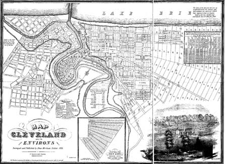
That survey of the Cleveland town site was the centerpiece of the Connecticut Land Company's marketing plan to create saleable lots in the Western Reserve. Moses Cleaveland, General Agent for the company, brought a surveying party to the Reserve in the summer of 1796 to create a mix of parcels that would sell quickly to prospective settlers back in the East and help raise operating revenue for the company. Leaving part of his surveying party in the eastern portion of the Reserve, to begin surveying the township lines, Cleaveland brought the rest of his party to the eastern banks of the Cuyahoga River to lay out the capital city of the Reserve.(3) The site had much to recommend it: it was the physical center of the Reserve, it commanded the critical river, lake and commercial routes and it provided a strategic position between the eastern areas open to settlement and the threat of British and Native American forces to the west, the intervening western portion of the Reserve then being still closed to settlement. To Easterners contemplating the purchase of lots in the Reserve, the location of Cleveland promised military safety and economic prosperity. The plat of Cleveland also offered the familiar appearance of a civilized village in the frontier wilderness, whose conservative pattern of streets and blocks lent assurances that competent developers were in charge who would be able to produce clear land titles, free of legal ambiguity and financial danger. In the tradition of the New England colonies, the land was being platted prior to sale, which helped prevent ownership ambiguities and, from the investors' perspective, un-saleable lands. On a number of levels, the original survey maps of the Connecticut Land Company were marketing tools to facilitate land sales to settlers and profits to the proprietors.
However, sales of township lots in the eastern portions of the Reserve soon were proceeding faster than were lot sales in Cleveland, partially due to higher prices here. Lots in the Youngstown and Warren areas could be had for $1-2, while the asking price in Cleveland was $25-50. Not until after the coming of the Ohio-Erie Canal in 1827 did Cleveland overcome this relative price disadvantage. It has been observed that the lure of the Trans-Appalachian frontier was not just that there was abundant land, but also that there were manifold opportunities in the new towns being formed. It took Cleveland a few decades to manifest these opportunities.(4) The settlement of Cleveland was also hampered by the fear of malarial "ague," supposedly caused by miasmic gasses emanating from the stagnant swamp at the mouth of the Cuyahoga. The actual cause was mosquitoes, but the results were the same: the settlers sought higher elevations farther south and east and caused the community of Newburgh, six miles to the south, to grow faster than Cleveland before the 1830s. One member of Cleaveland's surveying party, Nathaniel Doan, looked for his higher elevations four miles to the east. This location, in Hundred Acre Lot 402, was near where the main trail over the Reserve forded Doan's Brook and area became know as Doan's Corner (now Euclid Avenue between East 105th and East 107th Streets, immediately west of University Circle).(5) As Doan had been originally sent to the Reserve to provide blacksmith services for Cleveland, his soon-thriving outpost became and remained an important adjunct to the central urban economy. The Hundred Acre Lots surrounding Doan's Corners developed all the agricultural characteristics of the wider Reserve, but they also included a strong measure of economic activities that depended upon a proximity to Cleveland. This was true when the Corners served as the gateway to Cleveland in the first decades and it was particularly true after the Ohio-Erie Canal brought new prosperity, opportunities and competition to the Cleveland area after 1830. The Corners area witnessed new efforts from "downtown" Cleveland to reinforce and utilize its hinterlands in an attempt to beat back competition from its cross-river rival, Ohio City. Consequentially, this resulted in capital being invested that benefited the Corners as Cleveland's eastern gateway. Euclid Heights experienced some of the effects of this investment in the form of new roads, railroads and land speculation emanating from Cleveland and some trace of this investment is apparent in the palimpsest. Economic Activity in the CornersJust some of the economic activity originated in Cleveland, however, for the Corners area developed in great measure due to the efforts of its own residents. Local businessmen took advantage of their proximity to Cleveland and position astride the eastern trade routes to develop a series of small businesses to exploit these opportunities. In his 1930 reminiscences of Doan's Corners and the stories he heard about the area as a child, Charles Asa Post said that the first manufacturing concern in the area was a saleratus (baking powder) factory founded by Nathaniel Doan. This was followed by a grist mill owned by Samuel Cozad, a tannery by Elias Cozad, the Emery Clock Factory, and a "small laboratory plant" run by a Doctor Palmer to extract oil from cannel coal, all prior to the end of the Civil War.(6) This is consistent with Henry C. Binford's findings that the Antebellum suburbs of Boston were characterized by "... peripheral residents trying to exploit opportunities available at the city's edge-opportunities in suburban land speculation, small business, and unscheduled transportation." Small businesses, including Doan's smithy and tavern, were clearly an early component of the Corners, but local residents were eager to exploit opportunities in transportation and land speculation as well. Throughout the nineteenth century, the quest for profits in the East End would center on transportation and land speculation, which by the time of Euclid Heights Allotment were inseparably linked.(7)
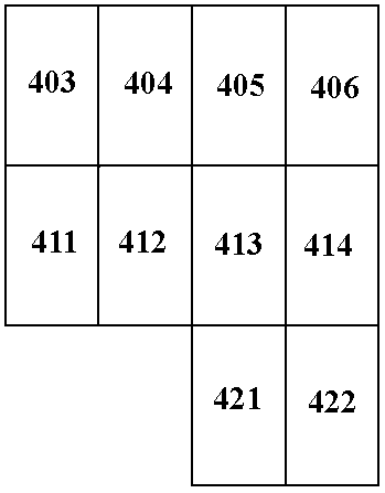
The first transportation links to Cleveland from Doan's Corners were by horseback, by wagon, and mostly by walking. Despite being outside the boundaries of the Cleveland "Walking City," the distances were not so great as to exclude frequent, if not daily, walking trips into town. According to Post, Leonard Case and his secretary use to walk out to the Corners and back to Cleveland, for exercise.(8) Wagons carrying produce and freight into Cleveland were another early form of transportation passing through the Corners and the creation of the Euclid Plank Road, a toll road, underscores the economic importance of this traffic. The Corners area served as a gateway to Cleveland along this road, providing travelers with food, lodging, and blacksmith services and was the site of one of the tollgates. Mayfield Road, another important commercial artery, was created by "An Act to lay out a State Road from Job Doan's, in Euclid, Cuyahoga County" in 1828.(9) The first form of public transit arrived in 1818, when weekly stagecoach service was inaugurated between Painesville and Cleveland. The trip took eighteen hours and required an overnight stop in Willoughby, so while it assisted regional travel, it did nothing to support daily commuting to Cleveland for work.(10) During the period from 1834 to 1849, another form of passenger service to Cleveland was in existence: the Quarry Railroad. Formally known as the Cleveland and Newburgh line, it was incorporated on 3 March 1834 by Cleveland's Mayor and a group of civic promoters, at least one of whom, Aaron Barker, was speculating in Corners land. The railroad was designed to haul bluestone ore and timber from a quarry on the Gale Farm up on Cedar Hill down to Cleveland. The trip down Cedar Hill was for freight only and was gravity powered. At today's East 101st Street the cars stopped at the Railroad Hotel, acquired a mule for power and added any passengers for the trip downtown. It ran two to six trips daily and was intended to later be steam powered. The line came into being just before the Panic of 1835, went bankrupt in 1840 and was kept alive until 1849 only because of large subsidies from the Cuyahoga County Commissioners.(11) Since the incorporators of the Quarry Railroad included James S. Clarke, the Mayor of Cleveland, perhaps the continued subsidies reflected the power of local politics. In the mid-1830s, Clarke was waging economic warfare with Ohio City speculators for control of the north bound traffic up the Wooster Turnpike and Ohio-Erie Canal, both for the benefit of Cleveland and for the benefit of a personal land development scheme he had near the Columbus Street Bridge. This rivalry cumulated in "The Bridge War" where rival booster groups engaged in hostilities.(12) The Quarry Railroad, like the Euclid and Mayfield plank roads would support the financial growth of Cleveland by increasing its access to the hinterlands. The Corners area was the gateway to Cleveland's eastern and southern (Newburgh) hinterland in the '30s and '40s, and witnessed a steady improvement in its transportation infrastructure, both from Cleveland investors and from Corners residents.(13) The next development in transportation was the omnibus service begun by Corners resident Ed Duty, in 1854. The omnibus was a variant on a stagecoach and his operated between downtown and the Croton House in East Cleveland. Later he extended it to Euclid Creek and another line reached Collamer via St. Clair in 1862. While running daily, these omnibus lines charged fares of 10 to 20 cents, far too much for the average city worker to afford on a regular basis.(14) Transportation and small business were two of the three methods that Binford identified in urban fringe economies like the Corners, the other being speculation in large estates. In the Antebellum period the owners of large tracts of land were frequently the leading business and professional men of the area, the symbiotic link between real estate and mass transportation not yet having been forged. Yet, the sale of real estate in the Euclid Heights has been an important part of the economy since the founding of the Western Reserve. Settlement of the Euclid Heights AreaThe first groups on the heights were the Connecticut proprietors and settlers. Most of the three million acres of the Reserve were distributed back to the proprietors of the Connecticut Land Company, in proportion to their ownership share in the company, by a complex series of drawings. The settlers could not purchase lots directly from the company, except in the Cleveland town site, but had to seek land from the individual proprietors. At the drawing, one group of proprietors headed by Judson Canfield drew an entity called "Tract IV," which consisted of an adjoining group of ten Hundred Acre Lots, including lots number 405, and 406 on Euclid Heights. Canfield's group went to court in 1812, seeking a further partitioning of Tract IV amongst themselves.(15)
Canfield received Lots 405 and 406 in his award, mortgaged it to John Adams, Jr., and Samuel Forbes that same year, and then in 1817 deeded the property to Samuel Flewelling, a frequent business associate. However, the mortgage went into arrears, perhaps due to the bank panic of this period, and Forbes and Adams' foreclosed. In 1829 their heirs finally obtained a Sheriff's Deed to the property, and started selling off the holdings.(16) Lot 405 they sold to Gordon Fitch and Aaron Barker in 1833 for $4,000, who mortgaged it with the Ohio Life Insurance Company two years later. Again a bank panic occurred, a mortgage was again in arrears and Ohio Life foreclosed on Fitch and Barker, receiving title to the property in 1842. Richard Wade has remarked on the tendency of land speculation to soak up the available capital in a local economy, leaving transportation companies starved for adequate financing. Perhaps Barker's involvement in both the Quarry Railroad and land speculation overextended him.(17) With the sale of Lot 405 to Cyrus Ford in 1847, for $1,853, the cycle of foreclosure ended. Ford held the property until 1855, when he began dividing it up between his three sons: Horace, Horatio and Henry. The Fords were one of the major landowning families of the Corners and leaders in the Euclid Avenue Congregational Church.(18) By similar processes, Hundred Acre Lot 406 and the western half of Original Lot 8 in Euclid Township ended up in the hands of the Andrew W. Duty, a member of another prominent landowning family in Doan's Corners. The patterns of the holdings of the first settlers were shaped by the lot lines of the original surveys and the subsequent land subdividing of this layer of the palimpsest merely added more lines. The new lots formed tended to be either square lots of ten to twenty acres along Mayfield or Cedar Roads, or they were long, narrow rectangles lying at right angles to the roads. The square parcels may have been level land intended for development (as one was, it will be shown), whereas the elongated parcels may have been intended for agriculture, where the turning of plow teams encouraged such elongated parcels.(19) By 1872, when the second layer of the Euclid Heights palimpsest starts to take shape, the first layer is complete in general form. The lines of the original surveys clearly mark boundaries between major parcels owned by the Fords and the Dutys. Within the Hundred Acre Lots, smaller parcels have been created, but reflect patterns of agriculture or general speculation, as no new internal roads have been installed and the parcels are still relatively large in size. New lines have been added, but none of the original survey lines have been obliterated in the process. This is a common pattern of development throughout the Western Reserve at the end of the Civil War. Meanwhile, like the sounds of Perry's guns a generation earlier, the economic reverberations of the "Bridge War" between the promoters of Ohio City and Cleveland were felt out on the urban fringe, at Euclid Heights and the Corners, as transportation improvements and land speculation were mustered to boost Cleveland's economy. All traces of the Quarry Railroad have been obliterated from the Euclid Heights palimpsest-except perhaps the emphasis on Cedar Glenn as an access route to the heights-but the Mayfield Plank Road alignment remains as testimony to the efforts to link Cleveland to its hinterland.
NEXT: Chapter III ã Copyright by William C. Barrow 1997 - All Rights Reserved BACK to thesis home page Last updated January 1, 1998 |
![[click here for enlarged version]](thesis02a.jpg)
![[click here for enlarged version]](thesis03a.jpg)