|
PREVIOUS: Chapter II CHAPTER III: THE 1870s AT DOAN'S CORNERS AND EUCLID HEIGHTS The second layer of the Euclid Heights palimpsest displays the first formal subdivisions to appear here: the modest efforts of small merchant investors to speculate in building lots. In the general prosperity following the Civil War, the growing economic base of the Corners and its proximity to Cleveland attracted more capital. Small businesses grew, public transportation became faster and more regular, and speculators were attracted to the prospects of rising land values. On Euclid Heights this resulted in changes in the 1870s that preserved all the previous property lines, but added a new kind of subdivision: the residential allotment.
While Cleveland grew rapidly in the decades between the coming of the Ohio-Erie Canal and the start of the Civil War, the rate of growth declined between 1830 and 1860. In the suburban hinterlands the rate declined more slowly, meaning that areas like Doan's Corners grew faster than did the central city. The rate of population growth between 1830 and 1860 fell from nearly 400 percent to just under eleven percent within the borders of the 1830 city, while the rest of Cuyahoga Count fell from 128 percent to just over 72 percent. Leading into the post-war period, the suburbs were the scene of growth and it was reflected in the economic activities springing up there.(1) Continued Small Businesses GrowthThe mix of new subdivision activities, public transportation, and entrepreneurial capitalism was growing rapidly on the Corners and new business growth was providing jobs to the area. By 1858, Cleveland's first malleable iron foundry was created north of Carnegie Avenue and Sherman Street (E. 100th Street), a decade before the better-known and more successful Cleveland Malleable Iron Company's creation, but it failed and was succeeded by the Jones Mowing Company. Another part of the former malleable iron foundry was used by a sorghum cane milling business.(2)
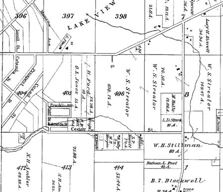
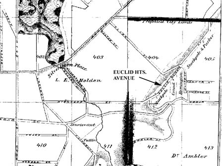
Closer to the heights, "Uncle Sammy" Cozad had a brickyard near present-day Wade Park, and Andrew Duty had one on Mayfield Road, at the base of the hill and across from today's Alta House. Binford identified brick making as best symbolizing the move to local manufacture from agriculture on urban fringes, with farm lands giving way to clay pits and drying yards.(3) Improvements in TransportationThe Corners were brought closer to the larger Cleveland economy in the 1860s and 70s as horsecars began operation out into the East End. Henry S. Stevens, operating under the name of the East Cleveland Railway Company, had run an omnibus service with Ed Duty after 1854. In 1859 he obtained a franchise from the City of Cleveland to operate a horse-drawn car on rails in Euclid Avenue, between Public Square and Willson Street. In 1863 he applied to have his franchise extended to Doan's Corners, but was rebuffed by concerns that this would compete with the Euclid Plank Road, so he only received permission to go out to E. 71st Street.(4) However, by 1871 he was allowed to extend a single track out to the Corners. According to the Titus company atlas of 1874, the East Cleveland tracks in Euclid Avenue had reached Lake View Cemetery where the line would maintain car barns for decades The horsecar, with a speed of about seven miles an hour, increased the distance a commuter could live from Cleveland by some two or three miles; bringing most of the East End up to Doan's Corners within a half-hour of downtown businesses. Euclid Heights, however, was still too far beyond this distance to enjoy easy commuting and the limited pulling power of horses made the trip up the hill at Cedar Glenn prohibitive.(5) The public transportation link to Doan's Corner and the Euclid Heights area was strengthened in 1873 when John D. Rockefeller, Stephen Harkness and others created a dummy railroad, the Lakeview and Collamer, to take passengers out to their water-cure resort and park. Harkness, a Standard Oil associate of Rockefeller's, was another who believed that the future of Cleveland laid to the east and had been buying up property beyond Willson Avenue along Euclid. Rockefeller's purchase of his eventually-beloved Forest Hill estate east of Lake View Cemetery, in 1873, was originally a speculative commercial proposition that only after its failure as a resort became the Rockefeller summer home. The Titus atlas of 1874 shows the railroad's tracks leaving East Madison (East 79th Street), running eastward along Lockyear Avenue for a block, then cutting cross private lands, parallel with Superior and finally turning north along Euclid Avenue, just beyond Lake View.(6) Henry Stevens and Edwin Duty of the East Cleveland Railway Company and most of the members of Rockefeller's dummy railroad board were residents of the Corners. This supports another of Binford's findings: that residents of urban fringe suburbs had long experience in exploiting their proximity to the city and were eager to establish better transportation links when the technology permitted.(7) Relationship of Transportation and ValueThe appeal of mass transportation technologies, like the horsecar, is that they allowed land speculators to realize gains in value faster than if they had to wait for the gradual population growth of an area to eventually reach their lands: a strategy sometimes called the "Astor Method," after Jacob Astor, who was famous for buying large parcels of country land around New York City during the Panic of 1837 and then waiting for growth to catch up. With public transportation the demand for country land could be rapidly satisfied by opening new lines.(8) Therefore, an investor could hope to turn his investment into profit much faster by buying lands in the path of new transportation routes, or by acquiring transportation lines and running them out to his country property, as Rockefeller and Harkness did. The revenue from streetcar lines was not the justification for investing in them, but rather their value came from their relationship to opening new areas for real estate development.(9) The horsecar line and the Rockefeller dummy railroad were the steps taken in the 1870s to bring real estate profits to the East End and Doan's Corners area. And with the extension of these lines to Lake View, Euclid Heights became subject to a new type of subdividing activity that constitutes the second layer of the palimpsest. Early Real Estate Development on the Heights: J.J. Low's AllotmentLate in 1870 Horatio Ford sold the southwestern 12 acres of Hundred Acre Lot 405 for $2,500 to Samuel Spangler, a "gentleman" then living on Cedar Avenue in East Cleveland. Spangler died soon thereafter and his executor deeded the property to Henry Weisgerber for $2,450 in June of 1871. A month later, Weisgerber, a confectioner whose home and shop were on Prospect Street, downtown, transferred title to John J. Low for $3,500, taking back a mortgage for $1,500 in the process.(10) In 1872 Low created the first residential subdivision on the heights, "J.J. Low's Allotment," which consisted of a main street running north from Cedar Road, called Cliff Street, two parallel dead-end streets running east from Cliff, named Edwards Street and Parker Street, and several rows of modest rectangular building lots.(11) Unlike the long, narrow lots that the Fords had created on the northern half of Hundred Acre Lot 405, fronting on Mayfield Road, Low's parcel in the southwestern portion was much more square in shape. It had its longer side facing Cedar Road and utilized only the level portions of the site for building lots. Someone reaching the crest of Cedar Glenn would be looking through the middle of Low's allotment, along the course now followed by Euclid Heights Boulevard.(12) Although there was some land lying in Hundred Acre Lot 404, between the lots fronting on the west side of Cliff Street and the ridge, Low did not own any of it. The streets, and therefore the majority of the lots, laid to the east of Cliff Street, and approximated the shape of a large capital "F" on the map. The reason for this configuration-as opposed, say, to one in which Cliff cuts through the middle of the subdivision-is not clear, unless further expansion to the east was envisioned.(13) More Development: Stackpole and Parker's AllotmentThe following year Low's allotment was joined to the north by a similarly-configured subdivision called Stackpole and Parker's Allotment. Cliff Street was extended farther north, a dead-end street named Franklin Street was run eastward and three rows of lots were laid out that were even smaller than Low's modest lots. But for the slight differences in lot sizes, the allotments of J.J. Low and of Stackpole and Parker appear to have been planned together, perhaps because it was cheaper to cross Low's than to circle it on adjoining property that Stackpole and Parker owned to the west. Each of the three residential streets -- Edwards, Parker and Franklin -- ended at the foot of a slight slope in the terrain.(14) CommentaryThe intended market for these early subdivisions is unclear. The contemporary subdivisions by Andrew Cozad at Euclid and Mayfield (1873), and a later one (1889) by Edmund Walton, next to Cozad's along Mayfield, eventually grew to be 96% Italian after Joseph Carabelli opened his stone masonry business near Lake View in 1880. These subdivisions were collectively known as Cleveland's "Little Italy," or the "Murray Hill" neighborhood. The modest simplicity of these subdivisions mirrors those of the two up on the ridge, to which they were connected by an extension of Cliff Street.(15) Little Italy's dependence upon the Carabelli works underscores the importance of jobs within walking distance of home for working-class Clevelanders in the 1870s, and these allotments were on the fringes of the Doan's Corners economy. They were convenient to few known sources of employment on the heights, besides the brickyards of Cozad and Duty, Worthy S. Streator's farm, Martin Gale's quarry, or Lake View Cemetery, which had been installed in 1869 and required some landscape workers.(16) Higher socioeconomic classes of people could live farther from work, because they could afford the streetcar fares, but in the early 1870s streetcars were still a decade away from cresting the heights. The wealthy could also afford the costs of maintaining horse-drawn carriages, but in the 1870s the fashionable addresses were still along lower Euclid Avenue and the few wealthy people who did own residences that far east, William J. Gordon for instance, had estates covering many tens of acres, not humble, seventh-acre lots.(17) Whatever the intended market for these lots, the allotments were undoubtedly hard hit by the Panic of 1873 and "long-wave" depression that waxed and waned until the mid-1890s. In his 1897 history of Cleveland, James Harrison Kennedy said of this period "The real estate market of Cleveland became utterly dead in a single day. Values were reduced, and sales as well as collections on former sales became impossible." If this was the situation city-wide, then poorly-targeted little allotments at the periphery may have suffered the most.(18) Biography: Low, Stackpole & ParkerPerhaps a wealthy individual or corporation could have weathered the economic storm, but there is no indication that Low, Stackpole or Parker were men of means. Little is know about them except what is found in city directories of the period. The first possible mention of Low was an entry in the directory for 1863-64, where a J.J. Low was listed as "Stewart's stove agent" and boarding at "the Water Cure." This J.J. Low, if indeed it was the same person, moved around East Cleveland township, and appeared one time as a gardener on Crawford Avenue. A John J. Low first clearly appeared in Cleveland city directories in 1871, as a partner in the real estate firm of Low, Simpson and Hopkins, and living in the East End, on the corner of Crawford and Hough. By 1874 (the last year examined during this period) Low was on his own in business and boarding at 900 Euclid Avenue.(19) The first directory entry for either of the other two real estate developers appeared in 1867, where a James Parker is listed as a lumberman living on Willson (East 55th Street). Although the directory intermittently listed other James Parkers, including a physician, a puddler, a saloon keeper and a piano tuner; and despite the lumberman being listed as living at one point in the new oil boom town of Titusville, Pennsylvania, the lumberman was listed as still living on Willson in 1872-3 when the allotment was created.(20) Thomas Stackpole first appears in the 1871-2 directory and is listed as a real estate man in the directory for the next year. In the 1873-4 directory he is still a real estate man, but his business affiliation is also listed as being J. McDermott and Company, manufacturers of building stone and grindstones. Unlike Low and Parker, Stackpole appears to have lived and worked downtown, and not in the East End.(21) These three pioneer real estate men on the heights appear to have come to their profession, as many have done in real estate, from other vocations. Low may have been a stove merchant, Stackpole a stone merchant and Parker a lumber merchant before becoming merchants of land. They came from respectable business backgrounds, ventured into the real estate market and generally remained there for some years without achieving much visibility. Compared to a truly successful real estate man like John G.W. Cowles, who represented John D. Rockefeller and Charles F. Brush and whose family owned a powerful newspaper (the Leader), Low, Stackpole and Parker were minor players in the local real estate scene.(22) Following the onset of the depression, some of the lots in these two subdivisions were purchased in batches by investors, or retained by the developers. J.J. Low's widow, Fanny, was still in possession of many of these lots in the 1890s, when she died.(23) Developer Improvements: Clark StreetHundred-Acre Lot 404 shows the course of a road that connected Euclid Avenue near Mayfield Road with the northern end of Cliff Street up on the heights. Named Clark Street, it is now the route of Cornell up to Murray Hill Avenue and Edgehill Road (approximately) from there to Overlook. It was laid out in 1872 by Horatio Ford and Andrew Cozad and required the permission of several other adjoining land owners to be dedicated for public use. Its apparent function was to connect these owner's properties to the East Cleveland horsecar line on Euclid Avenue.(24) The permission that Ford and Cozad needed from the other area landowners-Parker, Stackpole, Dudley A. Cozad, a local undertaker, and Frank Remington, an insurance agent who later became a clergyman in the Corners-was not hard to obtain, both because the road would benefit their properties, and because these men were working together on other speculative real estate ventures nearby. All were undoubtedly betting on the economic prosperity of the Corners, now that the horsecar was in place. The subdivisions they created were connected by Clark Street to the commercial node that would grow up around the intersections of Mayfield and Clark with Euclid, where the toll gate was located.(25) Planned Improvement: Euclid Heights AvenueThe second layer of the Euclid Heights palimpsest has one final element that should be mentioned, as it demonstrates that the name "Euclid Heights" dates to at least the 1870s. Two maps of this period show a road named Euclid Heights Avenue running along the ridge, starting at an extension of Highland, just north of Cedar Road; going across Clark Street about where Edgehill and Overlook intersect today; and ending at Mayfield Road. Drawn by one Otto Dercum, in 1873 and 1874, and unsupported by any maps not drawn by him, these maps may indicate an intention of Stackpole and Parker, who owned most of the land traversed by this route, to open more of their lands to development. The road was evidently never built, but it foreshadows further developments in the area, once the cycle of economic depression lifted two decades later. That introduces the main subject of this study, the Euclid Heights allotments of the 1890s.(26)
SummaryThe Atlas of Cuyahoga County, published in 1874 (Figure 7), is a good view of the second layer of the Euclid Heights palimpsest. It shows that lot 405 had become a complex of property lines and minor streets, reflecting the partitioning work of Cyrus Ford and the allotments of Low, Stackpole and Parker. Lot 406, and much of Lot 8, both to the west, were in the hands of Worthy S. Streator, who used them for his cattle breeding program. This layer contains the new property lines created with the installation of these small, speculative allotments which represent the attempts of local businessmen to profit from the closer economic and transportation connections between Cleveland and Doan's Corners community.(27) At this stage of evolution, all of the lines of the first layer of the palimpsest are still present. They framed and shaped the allotments of Low, Stackpole and Parker, which were too minor in scale to erase the earlier lines. But these allotments did herald a change in the basis of land values on the heights, from agriculture and small local businesses to residential suburbs of Cleveland. The changes were made possible by innovations in transportation technology which continued to dominate the economic future of the Corners area and Euclid Heights, as will be seen in the next layers of the palimpsest.
NEXT: Chapter IV ã Copyright by William C. Barrow 1997 - All Rights Reserved BACK to thesis home page Last updated January 1, 1998
|
![[click here for enlarged version]](thesis05a.jpg)
![[click here for enlarged version]](thesis06a.jpg)
![[click here for enlarged version]](thesis07a.jpg)