|
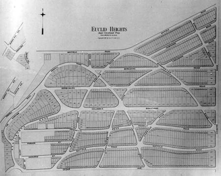
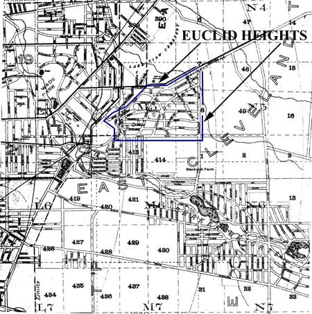
PREVIOUS: Chapter III CHAPTER IV: THE EUCLID HEIGHTS ALLOTMENT OF 1892 The third layer of the Euclid Heights palimpsest is the earliest of three layers displaying the Euclid Heights Allotment in its various forms, this being the recorded plat of 1892. It represents a strengthening of the relationship between public transportation and land development, and introduces several new elements to local land subdivision: a connection between subdivisions and public utilities, park development and land use controls. It also represents the return of out-of-state investors to the land title record of the Corners. The uncertain national economic recovery of the 1890s and delays in developing the nearby public park system retarded the development of the allotment in this configuration, and led to a re-subdividing of Euclid Heights several years later. Nevertheless, this version of the allotment left a permanent record on the palimpsest, one in which the earlier cadastral boundaries of the area were significantly altered for the first time.
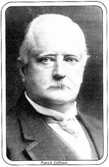
Patrick CalhounThe story of the Euclid Heights Allotment begins with Patrick Calhoun's purchase of the eastern portion of the site from Worthy Streator in 1891. This is the single largest acquisition of the lands comprising the allotment and Calhoun is the pivotal figure in the development company throughout its twenty year history. His arrival represents the infusion of eastern capital and ideas into the development of the heights, and parallels what was happening in Shaker Heights, with less success, by the predecessors to the Van Sweringen brothers.
The only account of Calhoun's arrival in Cleveland is told by his daughter, Mildred Calhoun Wick, and published decades after the event. She says that her father came to Cleveland in August of 1890, to attend a railroad meeting. Following the meeting he decided to visit the Garfield Monument, on the grounds of the Lake View Cemetery, which his family had helped finance. He was driven out to see the monument in a carriage driven by one John Hartness Brown, traveling out Euclid Avenue and up onto the heights above the monument via Cedar Glenn.(1) Mrs. Wick continues that her father was so impressed by the real estate activity that he witnessed on the drive out, and by the location and natural ambiance of the heights south of Lake View, that he insisted on purchasing the site from Streator that afternoon. He sent Brown to Streator with an offer of $30,000 and the deal was agreed to that same day. No evidence has been found to prove or disprove this account, beyond the bare fact that Streator sold the property to Calhoun, closing the deal in 1891. However, if Calhoun's arrival in Cleveland attracted little notice, he was gathering much national attention for his work in railroad syndication.(2) Patrick Calhoun was a grandson of United States Vice President John C. Calhoun and had been born in 1856 on the family plantation in South Carolina. Moving to Atlanta as a young man, he studied law and came to be senior partner in the law firm of Calhoun, King and Spalding. His specialty was railroad law and his firm was legal counsel for the Richmond Terminal, a Virginia railway holding company, in the 1880s. In 1892, at the age of 36, he was ousted from the Terminal Company, but was returned two years later as J.P. Morgan's agent. He represented the syndicate that bought the by-then-bankrupt Terminal Company and consolidated its constituent railroads into the Southern Railway System.(3) Like his famous grandfather, Pat Calhoun believed that the key to economic growth in the South was the ability of Southern ports, in competition with Philadelphia, New York and Boston, to develop rail links to the Midwestern industrial cities, like Cleveland. One of Calhoun's rivals within the Richmond Terminal machinations was Calvin S. Brice, an Ohio attorney who was a founder of the Nickel Plate Road and who maintained an office in Cleveland. Consequentially, the likelihood of Calhoun needing to come to Cleveland on railroad business at that time is quite high.(4) East End growthWhat is undeniably true is the assertion that Calhoun would have noticed, and been impressed by, Cleveland's growth into its East End. The Cleveland of 1890 was a far larger city than it had been twenty years earlier. The population had grown to 261,353, nearly three times the 1870 total, and five out of six were either first or second generation immigrants. The city encompassed 28 square miles and there were civic boosters calling for the annexation of Brooklyn, West Cleveland, Glenville and Collamer. In 1890 the Plain Dealer reported that: A ride over the street car lines that extend beyond Willson will reveal a building boom going on this season that augurs well for Cleveland.... They are beautiful edifices fit for the wisest, brightest or richest to inhabit, and they would not be common if they stood upon Euclid avenue lots, even in comparison with the mansions there.... All around, workmen are busy every day on new buildings.(5) In addition to the rapid pace of real estate development in the East End, there were two announcements that Calhoun might have noticed, and been influenced by during his August visit. First was the Board of Trade's call for a boulevard to link Gordon Park to Wade Park, which would have been Calhoun's introduction to the burgeoning issue of park expansion in Doan's Corners.(6) The other issue was an announcement that the East Cleveland Electric Railway Company was going to extend service from Quincy Avenue up to and along the ridge to the rear of the Garfield Monument. As this would bring more service to the heights, it would be a encouraging sign. The issues of parks and streetcars are central to an understanding of what Calhoun was attempting to do and need to be discussed in greater detail.(7) Parks and the Rural IdealWhen Euclid Heights was taking shape in the 1890s the ideal location for land was adjacent to parks. For prospective buyers of lots, the proximity to park lands symbolized that the pollution of the inner city was left behind for the healthful and spiritual benefits of suburban living, as envisioned in the Rural Ideal. For developers and investors, the ability to acquire land on the edges of a park -- or to get a park authorized next to land they already owned -- insured the profitability of their speculation.(8) The value of this close relationship between parks and profits was widely held and practiced by real estate promoters throughout Cleveland's history. Lee Canfield and Sheldon Pease donated Clinton Park to the city in 1835, to be the centerpiece of their luxurious Clinton Square development, near Lake Avenue and East Seventeenth Street. Subsequent railroad intrusions into the area, however, doomed the lakeside amenities of their project.(9)
[open browser window as wide as possible to see all of the next figure]
On the near west side, in Ohio City, Richard Lord and Elias Barber platted a subdivision, Barber and Lord's, in 1836. They situated a small greenspace, Franklin Circle, at the head of the main avenue and for many years the area rivaled Euclid Avenue as the prestigious address in Cleveland. In 1851, John G. Jennings created his University Heights Allotment in what is now the Tremont neighborhood on Cleveland's south side, and donated the small Pelton Park (later enlarged into Lincoln Park) to the city.(10) Further to the south and east, a syndicate of Buffalo investors was rumored to be interested in purchasing the former Shaker lands for development and were reportedly quite aware of the relationship between the success of their venture and the work of the park and boulevard commission in Doan's Brook. The Plain Dealer reported that "... the promoters of the scheme are very much interested in the boulevard project, and they realize that such an improvement in that vicinity would enhance the value of its realty."(11) Thus there was a cozy, symbiotic relationship between real estate developers and the public officials in charge of acquiring park lands. There was little competition for land between these two groups as their needs rarely overlapped and usually complemented each others goals. The developers wanted relatively level, easily-developed lands adjacent to parks for the enhanced values such proximity would bring, and were prepared to donate marginal lands to facilitate the presence of neighboring public parks. The public officials, mindful of the prohibitively high price of suburban lands suitable for real estate development, reluctant to retire property from the tax rolls, and desiring lands that were more picturesque and natural, were prone to seek more rugged, uneven terrain for parks. Hence the real estate speculators could split off land that they otherwise would have had trouble developing as residential lots and donate it for public parks. The public officials would thereby receive the more picturesque lands as parks without any expenditure of funds for capital acquisition.(12) The notion of relying upon wealthy benefactors for the acquisition of public park lands was not a new idea: for as far back as 1848 Andrew Jackson Downing had noted the lack of parks in the United States and had advocated the then-revolutionary idea of tax-supported parks for the benefit of all city residents; the land itself coming from the generosity of wealthy men.(13) Nor was the relationship between private land developers and public park officials unique to Cleveland. Sam Bass Warner observed that in Boston "... the Park Department carefully avoided land which was thought to be suited to private construction, taking instead the marshes and uplands at the edge of areas then building. In effect, the park Department landscaped the margins of private developments." In 1891, Cleveland's soon-to-be parks engineer, Ernest W. Bowditch, drew upon his Boston experiences in stating that: Although it may not appear self-evident it will be found on investigation that lands most desirable for park purposes are frequently not considered the best for residential uses, as they are apt to be too picturesque to be easily utilized and perhaps more difficult of access. Therefore the acquiring of park lands does not necessarily imply primary expenditures.(14) The heavy dependence upon private benevolence for capital acquisition assured that there would be little conflict and that the work of the public park commissioners in improving the private gifts would serve to "landscape the margins of private development." Despite the occasional, early complaints that this cozy relationship -- which might today be legitimized as a "public/private partnership" -- only served to benefit the wealthy land owners, the fact is that both parties benefited and needed each other for the realization of their individual ends.(15) Therefore by the 1890s it became standard practice for the developers of luxury subdivisions to donate any surplus, scenic lands to the growing local parks system in the expectation that the donation would be returned in the form of higher property values. Patrick Calhoun, Mrs. Martha B. Ambler of Ambler Heights, and the developers of Shaker Heights would all follow this practice in the East End during the decade. StreetcarsIf the location of the Streator farm, adjacent to the emerging park system, encouraged Calhoun to think of a luxury subdivision, it was nevertheless the circumstances of Cleveland's street railway system that must have impressed him most strongly. When he came to the heights in 1890, he was still primarily a steam railroad man, deeply involved in the affairs of the Richmond Terminal Company. But with his involvement with Euclid Heights, his destiny soon became electric streetcar systems and he went on to head street traction syndicates in St. Louis and San Francisco. Euclid Heights would remain his only known venture into direct investment in real estate development, but the link between streetcar values and land values would keep him in the traction business for decades after leaving steam railroads behind.(16) He may have become aware of the potential of street railways from his work in Richmond, where the first successful streetcar system was instituted in 1888. Frank J. Sprauge had been experimenting with electrified streetcars in New York City when financier Maurice B. Flynn hired him to create an electrified system in Richmond, VA, where Flynn had just won the traction franchise and was creating the Richmond Union Passenger Railway. The terrain was too hilly for horsecars and Sprauge experimented with new techniques until he perfected a working traction system and became "the Father of the Electric Trolley." His success was closely followed by investors and promoters, like Calhoun, and was quickly copied in other cities.(17) Cleveland had achieved some fame in the electric traction field before Sprauge had begun his work. In 1884, Edward Bentley and Walter H. Knight developed a method of delivering electricity to cars via charged rails in underground conduit and their East Cleveland Railway enjoined considerable publicity for two years as the first electric streetcar line in the U.S. before technical problems forced the closure of these experiments.(18) By the time of Calhoun's arrival, the East Cleveland line was in the second year of operation using the Sprauge electric traction system and was busily extending branches all through the East End. Calhoun, then, came from his personal experience of Sprauge's successes on hilly terrain to Cleveland, where the East Cleveland line was just announcing plans to run a branch up onto the heights. It was little wonder that Calhoun felt optimistic about the location of Euclid Heights and its potential as a streetcar suburb.(19) Another potential that might have attracted him was the traction franchise for Cleveland. In 1890 Cleveland was just entering a period of consolidation of its many traction franchises and this would have interested an investor like Calhoun. In 1885 two lines had combined to form the Woodland and West Side Railway Company and in 1889 two others merged into the Cleveland City Cable Company. By 1892 there were rumors that outside syndicates were interested in the Cleveland market, but that it was still too fragmented to acquire easily. The following year this was partially remedied when the East Cleveland line, the Broadway and Newburgh line, and the Brooklyn and South Side line were merged into the Cleveland Electric Railway Company, the "Big Con," and the Woodland and West Side line and the Cleveland City Cable line were merged into the Cleveland City Railway Company, the "Little Con." These two companies were further consolidated into the "Con-Con" in 1903, but even as early as 1890 the possibilities of consolidation would have been of interest to Calhoun, who subsequently went on to specialize in purchasing consolidated city streetcar lines in rapidly-growing cities.(20) There was a real market for streetcars in the 1890s. The marriage of traction technology and urban population growth served to drastically alter the suburban landscape as electric streetcars carried more people farther and cheaper than ever before and led to a proliferation of new allotments in the East End of Cleveland and in other U.S. cities.(21) In the first year of the Euclid Heights Allotment the horsecars were completely shouldered aside by the new electrics and by the city's centennial one writer observed: Electric Railways, with their 'Broom-stick trains,' have entirely done away with horse-cars within, and for miles without, our city limits. No horse-cars have run since July, 1893, the witches having taken full possession of all the lines, where their red-hot wires and brilliant sparks are often more suggestive of Pluto's regions than of public convenience.(22) The streetcars were a major force in shaping the late-nineteenth century city, but it was a shift towards increasing economic and social stratification. Exclusive, restricted allotments for the business, professional and social elite and the upper-middle classes of managers were installed at distances farther and farther from the immigrants, the poor, the workers and the ethnic minorities. What made the streetcar suburbs so attractive a proposition to speculators like Calhoun was that they were in demand by the more affluent middle-class buyers. Working class suburbs did exist, but were within close, walking distances from a few major employers, and were not the bourgeois "streetcar suburbs" which dominated Cleveland's East End.(23) The Euclid Heights Allotment of 1892 was designed to take maximum advantage of all these elements by presenting a designed community of several classes of building lots, offering electric streetcar service to Cleveland, utility lines in the streets and deed restrictions to insure compatible land uses. The idea, unlike that of the modest little allotments that had existed there in the 1870s, was to engineer an allotment of such high quality that buyers would feel assured that their investments would be protected and purchase lots in Euclid Heights instead of any of several competing subdivisions. Euclid Heights employed a sophisticated marketing mix of tangible and intangible attractions to build real estate value, which is reflected in this layer of the palimpsest. Euclid Heights: The SiteReal estate value has frequently been characterized as a function of location, and for Euclid Heights location meant two things: its lofty perspective from the ridge overlooking Doan's Corner and its position along the beautiful string of public parks then being planned. Stilgoe has traced the evolving nineteenth century appreciation of wholesome family living in the "Borderlands" around major industrial cities and identified "Heights" as one of the key elements of that evolving vision of the Rural Ideal. Looking west from their homes along The Overlook, wealthy Euclid Heights residents would not only feel apart of an elevated natural and moral landscape, but would see in the distance the pall of industrial progress from which they had escaped.(24) Like moral kings in their towering keep, they not only had the protection of distance and elevation, they were further buttressed by the public improvements which surround Euclid Heights. Across Mayfield to the north stretched the wooded splendor of the Lake View Cemetery, while to the west, below the ridge, was the new campuses of the Western Reserve College and the Case School of Applied Science. South of Cedar was the Ambler Heights allotment, also catering to a elite class of residents Cedar Glenn, then, led up to an idyllic aerie, beautifully framed by public parks and private institutions, that insured that obnoxious neighboring developments would not spoil the ambiance of Euclid Height. In this piece of inspired site selection, Calhoun was following the model of such national models as Roland Park.(25) To the east and south, as will be discussed later, Euclid Heights provided a good measure of buffer of its own: middle class lots and a golf course. The location of smaller lots in most of the northeastern portion of the plat meant that the lower residential values there -- which were, nevertheless, still under the control of Euclid Heights developers -- would shelter the higher values along the ridge and along most of Columbia Boulevard. To the south Calhoun installed a golf course which further buffered his project. Although created several years after the first plat was dedicated in 1892 -- it was hardly necessary as a buffer any earlier-it may have been a part of the planning from the beginning, particularly as the building lots designed for that portion of the plat where the course was located were never formally recorded.(26)
NEXT: Chapter V ã Copyright by William C. Barrow 1997 - All Rights Reserved BACK to thesis home page Last updated January 1, 1998
|
||||||||||

![[click here for enlarged version]](thesis08a.jpg)
![[click here for enlarged version]](thesis10a.jpg)
![[click here for enlarged version]](thesis11a.jpg)