|
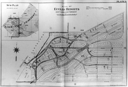
PREVIOUS: Chapter V CHAPTER VI: THE EUCLID HEIGHTS ALLOTMENT PLAT OF 1896 The fourth layer of the Euclid Heights palimpsest is the re-platting of part of the allotment in 1897. This re-platting accomplished several things: it removed all traces of the J.J. Low's Allotment and the Stackpole and Parker's Allotment from the contemporary maps and it created the Euclid Heights Boulevard configuration in their place. These actions had a major impact on the plat of 1892 and further underscored the importance of streetcar service to subdivisions. It was during this period that the Euclid Club was created, complete with a golf course spread over both sides of Cedar Road, although this may have been envisioned in the earlier plan. What emerges from this period is the Euclid Heights Allotment in its fully-developed form, substantially like what has survived to this day.
This period also marks a change in management of the Euclid Heights project. Calhoun alone remains from the 1892 group of principals and he is joined by William Lowe Rice who acts in a greater capacity than he has to date. The Railroad and Realty Security Company disappears and is replaced by the Euclid Heights Company and the Euclid Heights Realty Company as the corporate vehicles for managing the allotment in this phase. The actions taken by Calhoun, Rice and their new corporations will eventually lead to the economic collapse of their venture, due to unforeseen economic and social trends, but this layer must have represented the most optimistic moment for the developers of the allotment. But first the developers had to rescue their earlier version from the events of 1893. TransitionThe Euclid Heights Allotment of 1892 was undoubtedly affected by the Panic of 1893, as it would affect the project's development capital, the confidence and funding of prospective buyers and the financing needed to extend the electric streetcar lines into the allotment. Some attempt was made to sell lots in the original plat during the intervening period. In August of 1894, for instance -- one year after the initial series of big display ads -- Richard Parmely placed a short classified advertisement in the Plain Dealer saying: For Sale - Lots on Euclid Heights; water, sewer and all street improvements; no smoke, no dust; country air; city improvements; only 30 minutes from the square. 29 Richard M Parmely 140 Arcade.(1) The sale of lots was a slow proposition for several years after the first big promotions of 1892 and the first houses did not begin to appear until 1894, when architect Alfred Hoyt Granger is shown in the city directories as living there. Even the promoters of the project did not erect homes during the early years of the recession, probably due to the time necessary to install the streets and utilities. Brown is first listed as living in Euclid Heights in 1895, and Rice in 1896, formally opening his "Lowe's Ridge" estate the next summer. Calhoun, who had homes in several U.S. cities and two homes at different times in Euclid Heights, was living in town on Genesee Avenue in 1896 and did not officially bring his family to Cleveland until the century's turn.(2) By the publication of Mueller's 1898 atlas, only thirty-five property owners were shown on the Euclid Heights map and six of those had not built structures. This group gives an interesting view of the kinds of people initially attracted to lots in Euclid Heights, for it included nine men in business as merchants or managers; seven men in the real estate industry as builders, real estate promoters, or architects; six bankers or insurance men; three attorneys; one "Socialite;" one Teamster(!); two physicians and a physician's widow; and three members of Brown's family or Rice's law firm. Clearly the allotment's appeal was to the upper classes of professional and business men, many of whom were wealthy and socially-prominent.(3) The Euclid Heights that these men moved into, however, was not quite the same one that the John Hartness Brown group and the Railroad and Realty Security Company created in 1892. As the park boulevard came into being, linking Gordon and Wade Parks, the Euclid Heights developers re-designed the allotment to serve as a branch of the boulevard, leading buyers into the park allotment they envisioned. Euclid Heights Boulevard is testimony to their vision of a fast urban transportation system wedded to the rural ambiance of the picturesque parks to create a modern suburban residential allotment.(4) The Park SystemThe focal point of the park system development in the 1890s was the installation of the "Great Boulevard" to link Gordon Park on the lake front with Wade Park further upstream along Doan's Brook. The Board of Trade had called for such a boulevard in 1890, during the month Calhoun first visited the heights, and the topic monopolized everyone's attention for years thereafter. Boulevards were popular with developers everywhere in town and new allotments near them were promoted as having excellent prospects for increasing values. A real estate column in the Plain Dealer noted in 1894 that "out in Brooklyn the real estate business is booming just now, and the decision of the park and boulevard commission to place a park there has had much to do with enlivening the business." A display ad for this McArthur's Brooklyn Park Allotment included a map which showed that it was a rather ordinary gridiron plat that ran along the southern boundary of the new Brooklyn Park, underscoring the importance of proximity to the park in the marketing of this particular allotment.(5) In the East End, the creation of the magnificent new park and boulevard system in the 1890s drew real estate development with similar themes. A.G. Frisbee was offering lots in his Parkwood Allotment ("The Great Home Paradise"), pointing out that "the lake, Wade and Gordon parks are within five minute's walk in either direction." Nearby, Daniel R. Taylor, a major Realtor in Cleveland at the time, marketed his Doan Brook Boulevard Allotment on the basis of its proximity to the new boulevard connecting Gordon and Wade parks, and he prophesied that "the Doan Brook boulevard, which cuts off the west end of this allotment, will soon be begun and must advance values."(6)
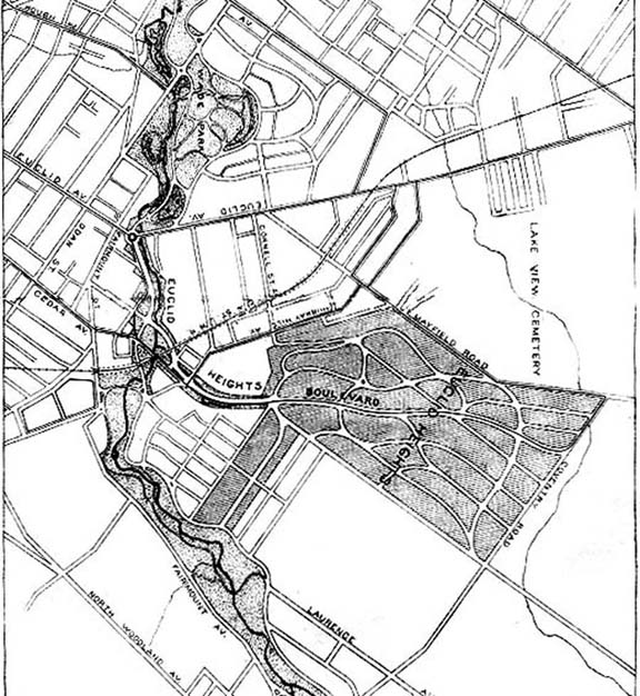
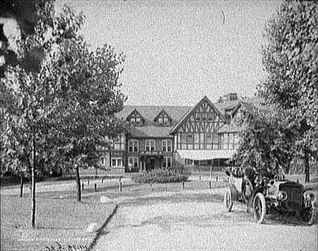
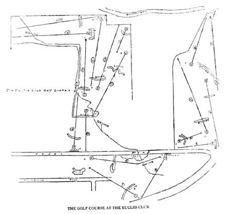
In Euclid Heights the benefits of park boulevards were so central to the marketing strategy that two major steps were taken to enhance the allotments association with the boulevard system. First was Calhoun's donation of land for the establishment of a formal entrance to the park system, which would double as the gateway to his Euclid Heights property, and second was the decision to re-plat the allotment to include the Euclid Heights Boulevard as a private continuation of the park boulevard. On 5 August 1896 Calhoun gave the city the much of the land necessary to provide the park system with a formal entrance for traffic. It included four hundred feet of frontage on Euclid and ran out to Cedar avenue and along Doan valley through Cedar Glenn. John Hartness Brown and Richard Parmely had been assembling the parcels for six months previously and the gift was valued at $160-170,000.(7) The gift, with lands from Rockefeller and the Case School, resulted in the creation of the University Circle which Calhoun intended to double as the entrance to Euclid Heights. He reserved the right to run streetcar tracks on a twenty-foot strip, which permitted the Cleveland Electric Railroad Company (the "Big Con") to extend its Euclid Avenue streetcar line across Deering, Stearns and Fairchild Streets, up onto the heights, and out along Euclid Heights Boulevard. The traction company received a franchise for this route on 5 October 1896.(8) Calhoun's donation followed shortly after John D. Rockefeller's major gift of land and money for the linking park boulevard (Liberty Boulevard, now Martin Luther King, Jr., Drive), and no doubt was intended to share some of the positive acclaim that Rockefeller received for his gift. The announcement of Rockefeller's gift had been made during the city's centennial celebration, where his agent, John G.W. Cowles, interrupted the proceedings to make the announcement to the applause of the crowd.(9) Calhoun's gift, however, while no doubt sincerely appreciated, was a cause of minor aggravation for both the city and Calhoun. For the city, the necessity of allowing streetcar traffic across Deering, Stearns and Fairchild Streets, south of the Circle, gave the Cleveland Electric Railroad Company an opportunity to attempt to abandon its Murray Hill Avenue line without performing some required street paving.(10) For Calhoun, it raised insinuations that he was only doing it to increase the value of his Euclid Heights property. Instead of receiving the sort of delegation of community leaders (which he had joined) that had visited Rockefeller after his gift, Calhoun had to send his attorney, William Rice, to defend to the park board the philanthropic nature of Calhoun's gift, saying: I feel that the fact that Mr. Calhoun is interested in a large body of land, as you know, which lies to the east of Cedar Glenn, and that he will undoubtedly derive a benefit by the enhanced value of that property should not in any way detract from the credit which is due to him for this gift to the city, because while he would share in the increased value, the owners of the property lying on the south of Cedar road and the property which you recall adjoins Mr. Calhoun's holdings on the east, will all be equally benefited. This plan, you will recall, was not Mr. Calhoun's, but was a plan for the opening of your park system originally designed by your Mr. Bowditch, and when Mr. Calhoun came to Cleveland, about four or five months ago, he was advised by some members of the board... that the city was not in a position now to have this magnificent opening to the general park system, owing to the fact that the funds which you had on hand were more than required in the improvement of the lands which you had already acquired....(11) The net results of Calhoun's gift, however, was to firmly connect Euclid Heights to the surrounding park lands which so beautifully framed it. The Plain Dealer remarked on the network of linked parks and Euclid Height's intimate association with them when it wrote that: The shape of the new system, embracing Gordon and Wade parks and Mr. Rockefeller's recent gift to the city, can be likened to the human arm, slightly bent at the elbow. The southern end, or Shaker lakes, might represent the hand, and Gordon Park the shoulder, with the elbow at a point where the boulevard, leading to the magnificent Euclid Heights property, enters the park system....(12) Some sort of grand promenade across the Euclid Heights plat had always been in the plans, but the linkage to the park system appears to have developed later. The 1892 plat of Euclid Heights had called for Columbia Boulevard to begin at the intersection of Edgehill Road and The Overlook (at John Hartness Brown's house), angle southeast to meet Kenilworth Road and then run due west across the plat to Coventry Road. While this boulevard would have been wider than the other roads running east and west, and while it would have been flanked by large, prominent lots for grand mansions, it lacked the graceful curves, median, and extra width of a true park boulevard. And it also lacked the streetcars running down the center that Euclid Heights Boulevard was subsequently given. During the period that Calhoun and his agents were assembling his gift of land for University Circle, they were also busy assembling the parcels necessary to remove the vestiges of the former J.J. Low's and Stackpole and Parker's Allotments from the top of Cedar Hill, where the lots blocked the proposed route of Euclid Heights Boulevard. All during 1896 and 1897 Calhoun was acquiring outstanding lots and passing the titles on to the Euclid Heights Realty Company.(13) The resulting transformation of the allotment can best be seen in the 1898 atlas of A. H.. Mueller, wherein the construction of Euclid Heights Boulevard and other streets is color-coded to indicate which were already installed and which were under construction. Worthy Streator reportedly had cleared large sections of the eastern portion of the plat for his breeding farm (selling the wood for the Mayfield Plank Road), but western parts of the boulevard clearly had to be cut through groves of trees, as can be seen in contemporary photographs showing the construction of Euclid Heights Boulevard.(14) The Euclid Heights Boulevard was a gently curving, divided parkway, with streetcar tracks running down the center. Later the line would be extended to Mayfield Road, via Coventry, giving rise to the Coventry shopping district. The boulevard, narrowed, would be extended through M. M. Brown's Mayfield Heights Allotment and out to Taylor Road opposite John L. Severance's palatial "Longwood" estate (later Severance Center Shopping Center). Brown (no known relation to John Hartness Brown) was so impressed by Euclid Heights Boulevard, and Calhoun's allotment generally, that his promotions traded greatly upon Mayfield Height's proximity to Euclid Height's amenities. In a half-page advertisement in 1896 he wrote: This allotment [Mayfield Heights] adjoins Euclid Heights on the east and the iron is now on the ground to bring the Euclid avenue cars past our land for one fare. A magnificent boulevard 100 feet wide, with graceful winding curves, has been laid out through Cedar Glenn and across Euclid Heights. The street cars will occupy 40 feet in the center of this boulevard, which will be a beautiful grass plot, decorated with flowers, and a paved park roadway 30 feet wide on each side with round curbing, making a drive unsurpassed for beauty and durability in this city. To all clear sighted people it is evident that Euclid Heights will in the near future be the finest residence portion of Cleveland, containing as it now does, the finest pavements and best improvements in the city. Mayfield Heights is separated from this unusual tract of land only by a street and its improvements will undoubtedly be extended to our land.(15) Brown's ad even reproduced testimonial letters that Calhoun had solicited and printed in the Euclid Heights promotional pamphlet. The Euclid Heights developers also flirted briefly with another form of transportation, one that would accelerate and reshape the suburban migration in coming decades: the automobile. In November of 1895 the Cleveland Press reported that Euclid Heights residents would soon be able to travel from the allotment to the center of town on horseless carriages designed by O. Rogers of Paris. Patrick Calhoun and his brother held the U.S. patents for the Rogers vehicle and envisioned a fleet of six such carriages carrying ten to fourteen people each at speeds up to 16 miles per hour. The scheme was dependant upon Rogers being able to install sufficient hill-climbing power in these gasoline-powered vehicles, else the enterprise would be abandoned. Evidently such power was not developed, for nothing more was heard of this scheme. However, coming only a year after the first automobile appeared on local streets, the notion of a private fleet of busses climbing hills and carrying commuters to the city center was a novel idea.(16) The Euclid ClubThe palimpsest of Euclid Heights contains a curious feature in all of its successive plattings, and that is the failure to dedicate the streets and building lots south of Berkshire Road, which nevertheless show up on the commercial maps of the period. Instead, the developers installed the Euclid Club, an elite country club on the grounds fronting on Cedar Road and built a club house on top a rise overlooking the entire allotment and the East End of Cleveland beyond. Whether this was in the original plans for the allotment -- and Bowditch had developed the Tuxedo Park allotment in New York with a county club prominent in the plans, before coming to Cleveland -- the Euclid Club was not formally created until after the first two allotment plats had been recorded.
The club was opened in July of 1901 and was limited to a membership of 400, reportedly with a long waiting list. It boasted Cleveland's second golf course, an eighteen hole course that began at the clubhouse, looped south and west across Cedar through lands that would later become the Wade Realty Company's Cedar Hill Allotment, then back to the clubhouse and continued south and east on lands acquired from Rockefeller, which are now the various Euclid Golf Allotments. The Tudor-styled clubhouse was designed by Meade and Garfield, the same firm that Granger had worked for before moving to Chicago.(17) The Euclid Heights Allotment was a large project for its day and required a considerable amount of capital to finance the preparation of the land for sales of lots. Bowditch's designs were undoubtedly expensive, surveys of the land had to be bought, and the installation of the infrastructure of graded and paved streets, street railway tracks, and utilities lines would have probably been the biggest cost to the developers. Sources cite $5,000,000 as the value of the improvements Calhoun was adding to the site, and one-fifth of that sum was reported borrowed from John D. Rockefeller, according to Calhoun's son-in-law.(18) Nothing approaching the $5 million dollar figure has been found in loans recorded with the County -- not necessarily the only authority -- but some funding can be documented. Certainly the acquisition of land, as discussed above, was usually done with the sellers agreeing to take back mortgages for the majority of the purchase price in most cases. This is a common method of preserving developmental capital, the mortgages being of short term and paid with funds from regular bank financing and the sales of lots. The Society for Savings had received a $60,000 mortgage from Brown and Parmely, as Trustees, in 1892, which was released in 1893. The Garfield Savings Bank had received one for only $6,000 from the Railroad and Realty Security Company, also in 1892. The larger loan may have been to finance the initial design and survey work, although its use was not specified in the mortgage documents.(19) The primary funding found for the allotment, however, was a bond issues with Rice's law partner, Edwin J. Blandin, who was acting as Trustee for potential buyers of the bonds. Secured by mortgages totaling $238,334, in 1894, the bonds were paid in full in 1897.(20) Funding for the payment of these bonds came from the largest recorded mortgage of all: one for $1,100,000 to the Cleveland Trust Company in 1897, which secured a bond issue of the Euclid Heights Realty Company. Under the terms of the issue, the realty company issued 1,000 bonds of $1,000 each, payable at the rate of 6% per annum and due on 1 September 1907.(21) President of Cleveland Trust in 1897 was John G. W. Cowles. His ties to Rockefeller may suggest some validity to the story that Rockefeller loaned Calhoun a million dollars, although the Rockefeller name is not mentioned in the recorded instruments. Cowles had participated in the creation of Euclid Heights six years earlier, built a home in the allotment in 1896, and upon assuming the bank's presidency in 1894 would have been interested in seeing the project succeed.(22) As it turned out, this loan proved to be the downfall of the Euclid Heights Realty Company, for the company's inability to meet the terms of the mortgage caused the bank to foreclose in 1914. Cowles had moved up to the chairmanship of the bank in 1903 and died in San Diego on the year of the foreclosure. It is not known what his role was in any of the bank's actions between 1897 and 1914 , while Euclid Heights stagnated for lack of sales and slid into bankruptcy.(23) SummaryThe fourth layer of the Euclid Heights palimpsest was created in 1897, showing the maturing vision that the developers had for the allotment in the era of public parks and electric streetcars. The installation of the Euclid Heights Boulevard radically changed the center of the 1892 plat, but tied the allotment closer to the growing suburban network of streetcar and park systems. The new plat erased the earlier allotments of Low, Stackpole and Parker from most maps, but not entirely from the underlying legal descriptions of the area. The Euclid Club was created in the area along Cedar Road, but the palimpsest retained the earlier, pre-1890 legal descriptions. These submerged, but official boundaries re-emerged in the next layer of the Euclid Heights palimpsest.
NEXT: Chapter VII ã Copyright by William C. Barrow 1997 - All Rights Reserved BACK to thesis home page Last updated January 1, 1998
|
![[click here for enlarged version]](thesis12a.jpg)
![[click here for enlarged version]](thesis13a.jpg)
![[click here for enlarged version]](thesis14a.jpg)
![[click here for enlarged version]](thesis15a.jpg)
![[click here for enlarged version]](thesis16a.jpg)