|
PREVIOUS: Chapter VI CHAPTER VII: BANKRUPTCY AND RE-SUBDIVISIONS AFTER 1896 The fifth and final layer of the Euclid Heights palimpsest displays the primary push to sell lots following the creation of Euclid Heights Boulevard and includes another recording of the plat, in 1907. This layer is an important view of Euclid Heights for it represents the outcome of the search for real estate values here in the decades following the creation of the allotment. Included in this layer are the foreclosure and Sheriff's sale of the allotment; the re-emergence of Edwards Street and lots from the earlier allotment of J.J. Low; the re-subdivision of portions of the Euclid Heights Allotment; the conversion of Euclid Heights' golf course to building sites; and the creation of commercial and apartment districts at two transportation hubs. This is the record of the marketplace imposing changes on the theoretical plans of Calhoun's development and offers suggestions that might not have been lost on the Van Sweringen brothers in their contemporary development of the Shaker Heights community.
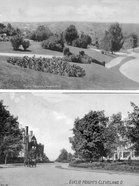
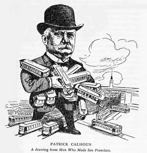
With the start of a new century and the opening of the Euclid Club, life in Euclid Heights was finally set for an anticipated splendid future. Gone were the lengthy delays caused by the slow installation of the park system and the economic collapse of 1893. There was a brief recession in 1901, but nothing noteworthy. John Hartness Brown had sold his interests in Euclid Heights and was busy developing an innovative office building downtown. William Rice had had his gala housewarming party for "Lowe's Ridge" and was running the Euclid Heights Realty Company. The long wait on the park system was over, Euclid Heights Boulevard was installed, the Euclid Club was open and important people were moving into homes along Overlook, Edgehill and Kenilworth. Patrick Calhoun, ever busy with projects around the country, was in St Louis in 1899 at the head of a syndicate buying that city's traction company. He had moved his family to Euclid Heights from Atlanta in 1896, but judging from his business activities, he must have spent a great deal of the time away from home.(1) Obligations from 1897 MortgageWhen the Euclid Heights Realty Company executed its mortgage to the Cleveland Trust Company, in 1897, it incurred certain obligations which carried over into the twentieth century. It was the realty company's inability to meet these obligations that led to its eventual downfall. The Euclid Heights Realty Company had issued 1,100 negotiable coupon bonds, worth $1,000 each, and bearing an interest rate of six percent per annum, payable twice yearly, in March and September. Cleveland Trust was the trustee and received a deed of trust to a large portion of the Euclid Heights Allotment as security for these bonds. The bonds were due and payable on 1 September 1907.(2) A similar mortgage and deed of trust was given to the American Trust Company (later named Citizens Savings and Trust) in 1898 to secure a $120,000 bond issue, due and payable two years from the issue date of 1 January 1898. The lots used to secure the latter trust deed were many of the same lots used to secure the earlier trust deed to Cleveland Trust, meaning that the latter mortgage was a second mortgage lien and any forced sale would be used to pay Cleveland Trust before American Trust received any reimbursement.(3) The first inkling of problems is found in 1904 when the Fourth Street National Bank of Philadelphia was awarded a judgment in federal court against the Euclid Heights Realty Company. This judgment was levied against the company and assigned to Cleveland Trust as trustees.(4) On 17 May 1907 the Euclid Heights Realty Company recorded another version of the Euclid Heights Allotment plat, under the terms of the 1897 trust deed to Cleveland Trust. The plat changed little, but still left blank the territory south of Derbyshire, between Euclid Heights Boulevard and Coventry Road. This area was evidently being reserved for use by the Euclid Club, its golf course, and Patrick Calhoun's mansion.(5) However, the Euclid Heights Realty Company did not perform on the most important condition of the trust deed, the payment of the outstanding bonds when they came due several months later, on 1 September 1907. Three weeks later the Cleveland Trust Company declared the Euclid Heights Realty Company in default under the terms of the trust deed and assumed control of the allotment.(6) It appears that Cleveland Trust retained control for a period of three years, collecting rents and incomes and made sales, until a supplemental agreement was reached with Euclid Heights Realty Company on 31 October 1910. As a result, the realty company made some payments to Cleveland Trust, which retired 115 of the outstanding 1,000 bonds and restored control of the allotment to the realty company.(7) The years preceding this supplemental agreement were tumultuous ones for the principles of the Euclid Heights Realty Company and may partially account for the problems that the allotment was undergoing. In 1906, one month after the San Francisco earthquake, Patrick Calhoun was awarded that city's traction franchise. He was the president of United Railroads, a large syndication, and rumor had it that the awarding was the result of payments made to the county supervisors. A major strike of streetcar workers occupied Calhoun's attention the following year and soon thereafter his local manager went on trial for the alleged bribery. Although the manager was acquitted, the prosecutors then went after Calhoun himself. Few felt that anything could be proven and the trial dragged on for the entire first half of 1909 before Calhoun, too, was acquitted. Prosecutors' appeals subsequently kept him busy until August of 1911.(8)
During most of this time, William L. Rice was President of the Euclid Heights Realty Company and in charge of local affairs. However, on the evening of 5 August 1910 he was murdered while walking home from the Euclid Club. The sensational inquest that followed turned up many theories, but the case was never solved. One noteworthy suspect was John Hartness Brown, who happened onto the scene moments after the murder and behaved strangely in the early hours thereafter. He also had a motive in that Rice had recently assumed control of the innovative office building that bore Brown's name, but Brown was found to have an unassailable alibi.(9) BankruptcyThe combination of Calhoun's trial and Rice's murder undoubtedly played a role in the diminishing fortunes of the allotment, even if the main reasons were economic. The agreement reached with Cleveland Trust on 31 October 1910 was soon in arrears as the realty company missed the scheduled tax payment for 1910. It also failed to make subsequent payments of taxes or interest and on 2 January 1912 Cleveland Trust declared the entire principal of the bonds due and payable and also paid the back taxes to protect its collateral from a forced tax sale. Two days later, on 4 January, it petitioned the courts for money foreclosure and relief from the Euclid Heights Realty Company and a list that grew to 123 other named individuals and corporations possibly having interests in the Euclid Heights Allotment. This was the beginning of the end for the realty company and for Calhoun's involvement in the allotment.(10) The defendants represented everybody who had any claims upon land in the allotment, which claims might affect Cleveland Trust's position as first lien holder. Included in this group were the current owners of Euclid Heights lots, banks holding judgments against the realty company and such institutions as the Euclid Club and St. Albans Church. Even the Village of Cleveland Heights was named.(11) The case continued throughout 1912, and on 7 August it established the amounts owed the various parties by the realty company, ordered the sale of the property and set the terms of the sale. The Cuyahoga County Sheriff was ordered to hold the sale at the corner of Edge Hill Road and Euclid Heights Boulevard and was told that he did not need to advertise it in any German-language newspapers. The property was to be sold, if possible, in its entirety or, failing in that, as 85 separate parcels. The selling price of each lot was to be no less than two-thirds the appraised value. The Cleveland Trust Company was adjudged the first and best lien holder and was to receive the first cut of the net proceeds. Matters concerning the rights of other parties to other lands was continued to another date.(12) With so many defendants, many more side motions were heard and matters resolved until 6 February 1914 when the court returned to the central issues. Here 34 defendants, including John Hartness Brown, were dismissed from the suit as having no interests in that portion of the Euclid Heights property affected by the lawsuit. Seventy-seven other defendants were found to have interests in the affected property: interests, however, which were secure from the claims of the Cleveland Trust Company.(13) Sixty-three of the latter group agreed to a uniform expiration date of 1 January 1934 for their deed restrictions: nineteen years sooner than most of them were originally scheduled to expire, but thirteen to eighteen years later than were some of the others. It is neither surprising that fifty property owners would be willing to shorten the dates of their deed restrictions, nor that the nine who refused the uniform date had restrictions scheduled to end earlier than 1934 -- owners are traditionally loathe to be constrained in the use of their property -- but it is surprising that 16 owners did agree to increase the lengths of their restrictions.(14) The Sheriff was again directed to hold the sale previously ordered, but now there were 175 parcels to be sold all at once or individually. Patrick Calhoun had obtained a side agreement to exempt from sale the undedicated portions of Derbyshire Road, Norfolk Road, Surrey Road, Mornington Lane and Overlook Lane, and these streets were legally established here by the court.(15) On the same day that this action was filed, the realty company gave a lease to the Euclid Club that was retroactive to the first day of October 1910 -- about two months after Rice's murder and one month before Cleveland Trust began foreclosure proceedings-and to run until the start of 1916. However the lands surrounding the club, excepting the newly dedicated roads and Calhoun's estate, was included in the 175 parcels subject to sale.(16) In the western portion of these unrecorded lands lying along Cedar Road, two elements of this layer of the Euclid Heights palimpsest emerged. In the corner of Cedar Road and Euclid Heights Boulevard, defendant Maud Stager Eells was deemed to own lands that were legally described in terms of the old J.J. Low's Allotment, the realty company never having established a new description for this area, and thereby returned to the current maps most of Edwards Street and the lots on its southern side.(17) This re-emergence of Edwards can be noted in the business atlases of the day, such as those produced by the Sanborn Map Company and the G. M.. Hopkins Company. In editions published before 1912, the entire intended Euclid Heights plat is shown, complete with numbered building lots where the Euclid Club's golf course then covered. The 1912 edition of the Hopkins plat book maps, however, shows the Edwards Street area as a pattern of dotted lines overlaying the Euclid Heights lots, and by 1914 the Edwards Street area is the only configuration shown. This recapitulates what was happening in the courtroom at the time, as Edwards Street was re-established as the legal description for the area.(18) The other palimpsest element established by these proceedings was something called "Plat A," which bordered the Edwards Street area to the east. This was apparently a legal device employed by the court to clarify the dedications of Derbyshire, Norfolk and Surrey in this area and is entered on the business atlases bearing the citation for this case in place of the usual allotment recordation information.(19) The sale date was finally set for 14 May 1914 at the Euclid Heights "Office Stop" at Edgehill and Euclid Heights Boulevard. Patrick Calhoun, who had reportedly been cruising in the Mediterranean before discovering the realty company's state of affairs, attended the entire two day sale, sitting in front of the auctioneer's stand checking off the lots sold on his map.(20) The auction did not obtain a bid on the entire 175 lots as one tract, and only sold 111 lots individually. This raised only $600,000 of the $1.6 million owed. Major purchasers of lots included Baruch Mahler, bond dealer; Henry W. S. Wood, President of Equity Savings and Loan Company; George R. Canfield, President of Canfield Oil Company; Samuel Scovil, President of the Cleveland Electric Illuminating Company; Harry L. Vail, former Cuyahoga County Commissioner; and two women, Mrs. Joseph DeRico, and Mrs. M.E. Delehanty, whose purchases were headlined the day following the conclusion of the sale. The 64 unsold lots were retained by the Cleveland Trust Company which contemplated selling them privately at a later time.(21) OutcomeThe Euclid Club did not survive the sale. Although its lease was due to run to 1916, it was merged with a successful rival, the Mayfield Country Club in 1914. Its demise opened the lands formerly occupied by its golf course and they were developed as the Abeyton Realty Company's Euclid Golf Allotment (1913), and the Wade Realty's Cedar Hill Allotment (1915).(22) After Rice's murder, John Hartness Brown moved to New York, was rumored to have later moved to London and was last known to be living in New York City during the 1940s. Calhoun spent some time trying to salvage his other investments around the country, but suffer a series of setbacks before finally recovering his financial health brokering an oil lease outside of Los Angeles in the 1930s. He was killed in 1943 by a speeding car in Pasadena, California. Brown's home still stands on Overlook in Euclid Heights, but Calhoun's Cedar Road mansion has been replaced by a church and Rice's "Lowe's Ridge" mansion was re-platted in the 1950s as the Kenilworth Estates subdivision.(23)
The decline in the fortunes of the Euclid Heights Realty Company, its principals and its allotment came while the automobile was entering a period of explosive growth. In 1901 the new Cleveland Automobile Club announced that there were at least 150 cars in use in Cleveland, but fifteen years later the registration of automobiles was ten times larger; an average annual growth of 17 percent. From 1916 to 1920 this growth accelerated to an annual rate of 176 percent, with 92,600 vehicles registered by the end of the period. By 1926 the number of cars registered topped 211,000, for a six-year average growth of 14 percent and a twenty-five year average of 33.6 percent per year.(24)
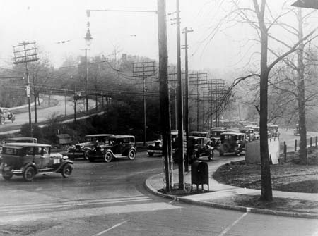
In 1890, the speed and power of the new electric streetcar had made commuting from Euclid Heights a feasible proposition for wealthier citizens. Here, near the end of the streetcar line, there was little prospect of arterial traffic passing through in objectionable quantities and the amount of land under the protective control of the developers was usually less than Euclid Heights' 300 acres. After 1920, however, the automobile changed the size and nature of residential real estate developments. Commute to work times could encompass more extensive territories and the heights could be opened up to many more people. Now the crest of Cedar Glenn was less a frontier line than a emerging gateway for traffic through Euclid Heights to the myriad of new allotments reached via Mayfield Road, Euclid Heights Boulevard, Cedar Road, and Fairmount Boulevard. By 1927 the top of Cedar Hill was called "perhaps the most congested highway on the East Side," a drastic change from 1893.(25) Also, the critical-mass of land necessary for a fully protected high-class community had expanded to allow for the geographic realities of automotive travel. The Van Sweringens' Shaker Heights community, which opened for sales in 1916, covered many times the area of Euclid Heights, with protective deed restrictions and a carefully planned network of curving streets and large lots. Perhaps only because the city's rapidly growth leveled off in subsequent years was Shaker Heights not overrun in the manner that Clinton Square and Euclid Heights, in turn, had been in their days. The fifth layer of the palimpsest may even display an acknowledgment of the changing influence of these two luxury communities. In 1922, part of the Euclid Heights Allotment at the corner of Coventry and Cedar was re-platted as the P. J. O'Donnell Allotment. Being quite close to the Van Sweringens' Fairmount Boulevard development, this symbolized the changing focus of fashionable living from Euclid Heights to Shaker Heights.(26) In some ways, the Van Sweringens took the community planning conventions of the previous decades -- as epitomized by Euclid Heights -- increased their scope to allow for a mixed automobile and rail application and created Shaker Heights at the new commute-to-work frontier. They had been paperboys in the heights during the start up of Euclid Heights and bicycle shop owners during the concurrent wheeling craze and had undoubtedly learned valuable marketing lessons about land use planning and transportation on the heights. One lesson that they surely learned was the necessity to plan for commercial uses near their residential areas. Due to the secluded, rural nature of Euclid Heights, no formal provisions were made for commercial land uses, such as apartment houses and retail stores. Along Mayfield Road the deed restrictions prohibited only the operation of saloons, so other commercial uses were evidently permitted, but this as a passive approach that may have had unforeseen consequences. As traffic increased into the heights, especially after the Euclid Club folded in 1916, commercial establishments began appearing along the southwest and the northeast borders of the allotment. This was not only due to automobile traffic, but also to the fact that these locations were the transfer points for streetcar passengers. In the northeast corner, the Euclid Heights and Mayfield lines intersected and allowed passengers an easy transfer after 1907. Near the former Euclid Club, Fairmount Boulevard was installed and the transfer point created there caused another commercial node to develop in the 1920s. Therefore, the growth of commercial centers in these two locations were a function of their roles as rail nodes.(27) How this influenced subsequent growth, after the failure of the Euclid Heights Realty Company, can be seen from an analysis of tax assessments during the 1920s. Examining the group of allotments immediately south of Cedar and the Euclid Heights Allotment -- which are quite similar in composition -- it can be shown that, between 1920 and 1924, the rates of growth of residential real estate values (as appraised by the County Assessor) were statistically the same in both areas, while the growth of commercial values were significantly greater. That is, the significant growth rate difference was not between residential lots in Euclid Heights and those in other allotments, but rather were between commercial lots and residential lots in Euclid Heights.(28) Thomas Adams observed in 1934 that the failure to make provisions for necessary commercial services will often tend to result in such services springing up in undesirable places. The commercial pressures on Euclid Heights, as it became a gateway to areas further into the heights, resulted in the growth of apartment houses, retail stores, and other service establishments, often to the detriment of the exclusive ambiance that Calhoun originally envisioned. This came after the bankruptcy of the realty company, but reflects trends in the demand for land uses all during the first dozen years of the twentieth century. Calhoun had foreseen both the use of gasoline-powered commuter vehicles, with his 1895 omnibus idea, and as early as 1892 was authorizing sales ads that acknowledged that Euclid Heights "... is in the East End, now well to the East, but one day to be only Central in the great and populous East End of Ultimate Cleveland." It's likely that he planned for Euclid Heights to be a protected enclave, full of magnificent homes, before rival developments like Shaker Heights could come into demand. But the economic delays of the period, coupled with his troubles in San Francisco and Rice's murder, caused the Euclid Heights Allotment to miss its opportunity to prosper as a streetcar suburb development before the automotive suburb's time came.(29) The fifth layer of the Euclid Heights palimpsest reveals the problems that beset the development as slow sales caused the realty company to miss it's marketing and financial schedules and fall into bankruptcy. From the bankruptcy came the re-emergence on the maps of Edwards Street and some of the building lots from the earlier J.J. Low's Allotment. It also necessitated re-plattings in the area of the Euclid Club along Cedar Road, like P. J. O'Donnell's Allotment and "Plat A." From the growth of the heights -- enhanced by the automobile -- came the growth of commercial and apartment nodes, with corresponding changes in the configuration of lot lines near Coventry and Mayfield and near Cedar and Fairmount. These changes reflected changes in land use and altered the cartographic representation of Euclid Heights in this layer of the palimpsest. But it is a credit to the planning of the allotment that the Euclid Heights Allotment today is not so very far from what Patrick Calhoun and his associates first envisioned: a lovely neighborhood of fine homes.
NEXT: Chapter VIII ã Copyright by William C. Barrow 1997 - All Rights Reserved BACK to thesis home page Last updated January 1, 1998
|
![[click here for enlarged version]](thesis17a.jpg)
![[click here for enlarged version]](thesis18a.jpg)
![[click here for enlarged version]](thesis19a.jpg)
![[click here for enlarged version]](thesis20a.jpg)